IMAGES TAKEN NEAR TO
Church Street, BISHOP AUCKLAND, DL14 7RZ
Introduction
This page details the photographs taken nearby to Church Street, DL14 7RZ by members of the Geograph project.
The Geograph project started in 2005 with the aim of publishing, organising and preserving representative images for every square kilometre of Great Britain, Ireland and the Isle of Man.

There are currently over 7.5m images from over14,400 individuals and you can help contribute to the project by visiting https://www.geograph.org.uk
Image Map
Images are licensed for reuse under creativecommons.org/licenses/by-sa/2.0
Notes
- Clicking on the map will re-center to the selected point.
- The higher the marker number, the further away the image location is from the centre of the postcode.
Image Listing (7 Images Found)
Images are licensed for reuse under creativecommons.org/licenses/by-sa/2.0
Image
Details
Distance
1
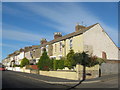
Jubilee Street Toronto County Durham
Image: © Peter Robinson
Taken: 25 Oct 2010
0.04 miles
2
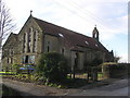
St. Pauls on the Hill : Toronto
Former Church (now a private residence) (dated 1903). Toronto was named by WC Stobart (after the Canadian City) whose mining company built the village (1859) for the miners and their families. By 1894, Toronto Colliery was working four seams, with 500 men and boys employed. The colliery closed in the late 1920's, and reopened by the Bitchburn Fireclay Co.Ltd in 1937. At its peak in 1950, it employed 119 men. In 1967, it employed 70 men and 18 pit ponies, but closed soon after.
Image: © Hugh Mortimer
Taken: 21 Jan 2007
0.11 miles
3
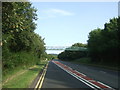
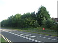
Foot bridge over the A689, Toronto
Looking south east.
Image: © JThomas
Taken: 24 Aug 2017
0.15 miles
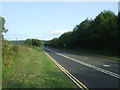
7
The upper car park, Kynren, Bishop Auckland
Image: © habiloid
Taken: 31 Aug 2024
0.24 miles