IMAGES TAKEN NEAR TO
Woodland, BISHOP AUCKLAND, DL13 5RZ
Introduction
This page details the photographs taken nearby to DL13 5RZ by members of the Geograph project.
The Geograph project started in 2005 with the aim of publishing, organising and preserving representative images for every square kilometre of Great Britain, Ireland and the Isle of Man.

There are currently over 7.5m images from over14,400 individuals and you can help contribute to the project by visiting https://www.geograph.org.uk
Image Map
Images are licensed for reuse under creativecommons.org/licenses/by-sa/2.0
Notes
- Clicking on the map will re-center to the selected point.
- The higher the marker number, the further away the image location is from the centre of the postcode.
Image Listing (5 Images Found)
Images are licensed for reuse under creativecommons.org/licenses/by-sa/2.0
Image
Details
Distance
1
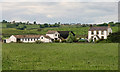
Burfoot Leazes
Burfoot Leazes Farm.
Image: © Peter McDermott
Taken: 12 Jun 2010
0.01 miles
2
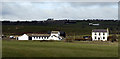
Burfoot Leazes
The farm at Burfoot Leazes from the south at a forest road on the north side of Arn Gill.
Image: © Trevor Littlewood
Taken: 26 Feb 2012
0.02 miles
3
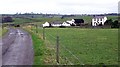
Burfoot Leazes
Raby Estates Farm off Steele Road. The West end of Woodland Village on the horizon.
Image: © Hugh Mortimer
Taken: 25 Feb 2007
0.02 miles
4
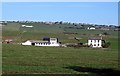
Burfoot Leazes Farm
The village of Woodland is seen on the skyline. The many white-painted farm buildings are typical of this area.
Image: © Roger Smith
Taken: 5 Apr 2009
0.02 miles
5
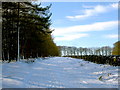
Track above Arn Gill
A very good track leads from the Gaunless bridge south of Coply, west on the ridge between Hindon and Arn Becks, eventually leading to Langleydale Common. In the conditions shown, it would have made a very good nordic ski tour, as the snow, whilst shallow, was very cold in the shade of the plantation, and nicely compacted by a set of landrover tracks. The route is only a public footpath, despite being a much better track than the bridleway to the north Image
Image: © Andy Waddington
Taken: 11 Feb 2010
0.20 miles