IMAGES TAKEN NEAR TO
Woodland, BISHOP AUCKLAND, DL13 5RS
Introduction
This page details the photographs taken nearby to DL13 5RS by members of the Geograph project.
The Geograph project started in 2005 with the aim of publishing, organising and preserving representative images for every square kilometre of Great Britain, Ireland and the Isle of Man.

There are currently over 7.5m images from over14,400 individuals and you can help contribute to the project by visiting https://www.geograph.org.uk
Image Map
Images are licensed for reuse under creativecommons.org/licenses/by-sa/2.0
Notes
- Clicking on the map will re-center to the selected point.
- The higher the marker number, the further away the image location is from the centre of the postcode.
Image Listing (8 Images Found)
Images are licensed for reuse under creativecommons.org/licenses/by-sa/2.0
Image
Details
Distance
2
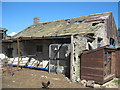
Derelict farmhouse at Foster Hill Woodland
Now surrounded by kennels, shelters and storage buildings
Image: © Peter Robinson
Taken: 22 Aug 2010
0.18 miles
3

Woodland : Cemetery and War Memorial
On the north side of Middleton Road.
Image: © Hugh Mortimer
Taken: 25 Feb 2007
0.23 miles
5
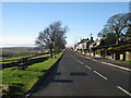
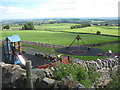
B6282 through Woodland
Road through village with Woodland Fell in the background
Image: © Rebecca Beeston
Taken: 4 Dec 2009
0.24 miles
6
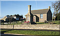
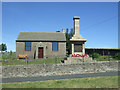
War memorial at Woodland
Woodland's war memorial resembles a chimney! The building behind it is presumably a chapel of some kind.
Image: © Trevor Littlewood
Taken: 16 Dec 2021
0.24 miles
7
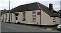
Woodland : Assembly and Reading Rooms
On the south side of Middleton Road. A plaque reads; 'Assembly and reading rooms erected by the, Woodland Collieries Company Ltd. For the use of their men. 1891'.
Image: © Hugh Mortimer
Taken: 25 Feb 2007
0.24 miles