IMAGES TAKEN NEAR TO
Butterknowle, BISHOP AUCKLAND, DL13 5JD
Introduction
This page details the photographs taken nearby to DL13 5JD by members of the Geograph project.
The Geograph project started in 2005 with the aim of publishing, organising and preserving representative images for every square kilometre of Great Britain, Ireland and the Isle of Man.

There are currently over 7.5m images from over14,400 individuals and you can help contribute to the project by visiting https://www.geograph.org.uk
Image Map
Images are licensed for reuse under creativecommons.org/licenses/by-sa/2.0
Notes
- Clicking on the map will re-center to the selected point.
- The higher the marker number, the further away the image location is from the centre of the postcode.
Image Listing (3 Images Found)
Images are licensed for reuse under creativecommons.org/licenses/by-sa/2.0
Image
Details
Distance
1
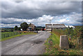
Trig point with High House
The foreground trig point is known to the OS as Blue House. High House and its associated buildings lie beyond.
Image: © Trevor Littlewood
Taken: 27 Jul 2014
0.06 miles
2
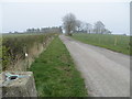
Track from High House to road
Looking north-eastward from the Triangulation Pillar.
Image: © Peter Wood
Taken: 28 Mar 2017
0.11 miles
3
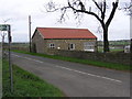
New Blue House : Morley
New Blue House was built as a byre, and until the 1960's was in use as a non-conformist chapel, now a private house.
Image: © Hugh Mortimer
Taken: 5 Nov 2006
0.17 miles