IMAGES TAKEN NEAR TO
Satley, BISHOP AUCKLAND, DL13 4HZ
Introduction
This page details the photographs taken nearby to DL13 4HZ by members of the Geograph project.
The Geograph project started in 2005 with the aim of publishing, organising and preserving representative images for every square kilometre of Great Britain, Ireland and the Isle of Man.

There are currently over 7.5m images from over14,400 individuals and you can help contribute to the project by visiting https://www.geograph.org.uk
Image Map
Images are licensed for reuse under creativecommons.org/licenses/by-sa/2.0
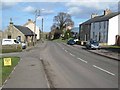
Notes
- Clicking on the map will re-center to the selected point.
- The higher the marker number, the further away the image location is from the centre of the postcode.
Image Listing (18 Images Found)
Images are licensed for reuse under creativecommons.org/licenses/by-sa/2.0
Image
Details
Distance
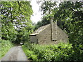
1
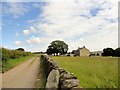
Steeley Farm at Satley
Farm north of the village. It has a big solid looking farmhouse, probably mid Victorian.
Image: © Robert Graham
Taken: 13 Jul 2016
0.02 miles
2
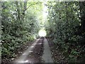
Sunken lane, Satley
Little lane west of the village, leading to East Butsfield Lane.
Image: © Robert Graham
Taken: 13 Jul 2016
0.07 miles
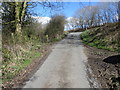
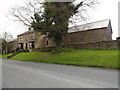
3
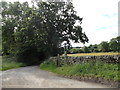
Country lane near Steeley Farm, Satley
This winding lane runs west from the village main road to join with East Butsfield Lane. The footpath on the right leads back into the village.
Image: © Robert Graham
Taken: 13 Jul 2016
0.07 miles
4
House near Satley
Presumably a converted chapel. In the valley of the Steeley Burn, just below Satley.
Image: © Oliver Dixon
Taken: 6 Mar 2007
0.09 miles
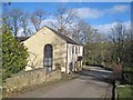
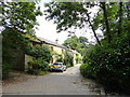
5
Cottage at Satley Grove
This little building is right beside the Steeley Burn, and may have been part of a mill complex at one time.
Image: © Robert Graham
Taken: 13 Jul 2016
0.09 miles
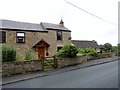
6
Satley Grove
This is a former quarry workers house at the north end of the village of Satley. It is a listed building with a date 1812 carved on the door lintol.
Image: © Robert Graham
Taken: 13 Jul 2016
0.13 miles
7
Former farmhouse in Satley
This is Mill Farm, on the north side of the village. Does not appear to be a working farm now.
Image: © Robert Graham
Taken: 29 Jul 2016
0.18 miles
8
Minor road joining the B6296
Looking north-eastward.
Image: © Peter Wood
Taken: 31 Mar 2017
0.19 miles
9
Satley
A remote village in western County Durham. http://www.durham-pa.gov.uk/durhamcc/K2P.nsf/K2PDetail?readform&PRN=D6873
Image: © Oliver Dixon
Taken: 6 Mar 2007
0.20 miles
10
The farmhouse of North Farm, Satley
Facing directly onto the main street through the village. This would have been the usual setting for farms in agricultural villages such as Satley in early times. Satley has medieval origins although the surviving buildings are C18 or later. This house is probably early C19, but occupying the same place as earlier farmhouses.
Image: © Robert Graham
Taken: 13 Jul 2016
0.20 miles