IMAGES TAKEN NEAR TO
Satley, BISHOP AUCKLAND, DL13 4HS
Introduction
This page details the photographs taken nearby to DL13 4HS by members of the Geograph project.
The Geograph project started in 2005 with the aim of publishing, organising and preserving representative images for every square kilometre of Great Britain, Ireland and the Isle of Man.

There are currently over 7.5m images from over14,400 individuals and you can help contribute to the project by visiting https://www.geograph.org.uk
Image Map
Images are licensed for reuse under creativecommons.org/licenses/by-sa/2.0
Notes
- Clicking on the map will re-center to the selected point.
- The higher the marker number, the further away the image location is from the centre of the postcode.
Image Listing (29 Images Found)
Images are licensed for reuse under creativecommons.org/licenses/by-sa/2.0
Image
Details
Distance
1
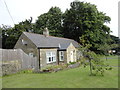
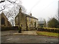
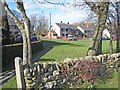
The Lodge, Satley
This nice little stone cottage stands beside the village main street. It appears to be second half of the C19 in date, and was perhaps the lodge for the vicarage, which is behind it.
Image: © Robert Graham
Taken: 13 Jul 2016
0.03 miles
2
Storage yard, Satley
Just behind the main street in the village. Perhaps the base for a builder specialising in the restoration of old stone properties.
Image: © Robert Graham
Taken: 13 Jul 2016
0.04 miles
3
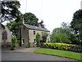
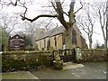
Former school house at Satley
Beside the village church.
Image: © Robert Graham
Taken: 13 Jul 2016
0.06 miles
4
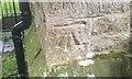
Ordnance Survey Cut Mark
This OS cut mark can be found on the south face of St Cuthbert's Church. It marks a point 237.973m above mean sea level.
Image: © Adrian Dust
Taken: 18 Sep 2018
0.06 miles
5
St Cuthbert's church, Satley
This is the village church for this little settlement on the road between Tow Law and Lanchester. It dates from 1870, when it was rebuilt from a ruin.
Image: © Robert Graham
Taken: 6 Mar 2013
0.07 miles
6
The Old School House, Satley
This was the village school from 1846 until 1965. There is no school in the village now, chlidren have to go to Wolsingham or Tow Law.
Image: © Robert Graham
Taken: 6 Mar 2013
0.07 miles
7
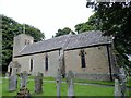
Satley parish church
This is the Victorian church of St Cuthbert, rebuilt in 1870 from a ruined C18 one.
Image: © Robert Graham
Taken: 13 Jul 2016
0.07 miles
8
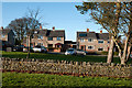
Houses in Satley
These houses at the south end of the village would doubtless have been built as 'council houses', what would now be known as social housing. Most of these properties will now, surely, be owner-occupied.
Image: © Trevor Littlewood
Taken: 9 Dec 2012
0.08 miles
9
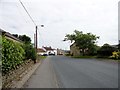
Satley
Modern housing is concentrated at the top end of the village.
Image: © Oliver Dixon
Taken: 6 Mar 2007
0.08 miles
10
View down Satley main street
Looking north up the street to the Punch Bowl pub. Satley village is set out in a linear fashion along this street, and this is thought to denote its medieval origins.
Image: © Robert Graham
Taken: 13 Jul 2016
0.09 miles