IMAGES TAKEN NEAR TO
Hedley Hope, BISHOP AUCKLAND, DL13 4BW
Introduction
This page details the photographs taken nearby to DL13 4BW by members of the Geograph project.
The Geograph project started in 2005 with the aim of publishing, organising and preserving representative images for every square kilometre of Great Britain, Ireland and the Isle of Man.

There are currently over 7.5m images from over14,400 individuals and you can help contribute to the project by visiting https://www.geograph.org.uk
Image Map
Images are licensed for reuse under creativecommons.org/licenses/by-sa/2.0
Notes
- Clicking on the map will re-center to the selected point.
- The higher the marker number, the further away the image location is from the centre of the postcode.
Image Listing (3 Images Found)
Images are licensed for reuse under creativecommons.org/licenses/by-sa/2.0
Image
Details
Distance
1
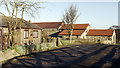
Farm buildings at Low West House
Low West House is a farm in the upper Deerness Valley. The bungalow to the left of the image seems to be a relatively recent addition - it's not shown presently on OS maps at all scales.
Image: © Trevor Littlewood
Taken: 13 Jan 2012
0.01 miles
3
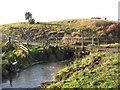
Farm bridge over River Deerness County Durham
Just south west of Low West House Farm near Tow Law
Image: © Peter Robinson
Taken: 25 Nov 2009
0.11 miles