1
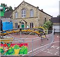
Wolsingham Baptist Church
This chapel was opened in 1831 and enlarged in 1889.
Image: © Alan Murray-Rust
Taken: 10 Nov 2009
0.04 miles
2
The Baptist Church, Wolsingham
An article in 'Durham Town & Country' magazine (Autumn 2007) says that this is the only Baptist Church in Weardale and was founded in 1830.
Image: © Bill Henderson
Taken: 15 Nov 2007
0.04 miles
3
Peel Cottage, Market Square, Wolsingham
Peel Cottage was named after Sir Robert Peel and was the first police station in Wolsingham. It still retains a blue lamp in the front garden and a bell above the upper window. The nearest police station is now in Crook.
Image: © Andrew Curtis
Taken: 2 Sep 2011
0.05 miles
4
The Baptist Church, Market Place, Wolsingham
This is the only Baptist Church in Weardale, established in 1830 and enlarged in 1889 to incorporate a schoolroom. There is a graveyard to the rear. There is another view here
Image and one without the paraphernalia of the funfair here
Image
Image: © Andrew Curtis
Taken: 2 Sep 2011
0.05 miles
5
The Baptist Church, Market Place, Wolsingham
There is a description here
Image
Image: © Andrew Curtis
Taken: 2 Sep 2011
0.05 miles
6
Not a ram raid
Not a ram raid, nor closure of yet another small town bank. Early on Saturday 26 May 2007, the west end of Wolsingham town centre was devastated when an oxy-acetylene cylinder being carried in a Transit van exploded. Many windows were blown out and several buildings sustained structural damage. The driver was killed, but fortunately, being early on a Saturday morning, nobody else was about, and there were no other casualties. http://news.bbc.co.uk/1/hi/england/6700103.stm
Image: © Oliver Dixon
Taken: 31 May 2007
0.05 miles
7
Wolsingham Market Square
Looking from East End, with the Black Bull at the left. The local bus is run by Weardale Motor Services. This is one of relatively few old established small bus operators still running its original service.
Image: © Alan Murray-Rust
Taken: 10 Nov 2009
0.05 miles
8
Millstone Place, Wolsingham
Lane parallel to Front Street leaving an isolated narrow island of buildings on the left side
Image
Image can be seen at the far end of the lane.
Image: © Andrew Curtis
Taken: 2 Sep 2011
0.05 miles
9
The Black Bull Pub, Wolsingham
Image: © Bill Henderson
Taken: 15 Nov 2007
0.06 miles
10
Converted Primitive Methodist Chapel, Front Street, Wolsingham
Three-storeyed chapel, otherwise known as The Gallery, designed by local architect George Race, a prominent Primitive Methodist, and built in 1885. It was built on the site of a former blacksmith's shop, with stone quarried from the nearby Redgate quarry.
National Heritage List for England Entry Number: 1233234 https://www.historicengland.org.uk/listing/the-list/list-entry/1233234
The chapel went out of use in 1983 and its interior fittings were taken to the USA. It has been sensitively converted into three apartments.
The Black Bull pub is to the right
Image
Image: © Andrew Curtis
Taken: 2 Sep 2011
0.06 miles


