IMAGES TAKEN NEAR TO
Church Lane, BISHOP AUCKLAND, DL13 3AN
Introduction
This page details the photographs taken nearby to Church Lane, DL13 3AN by members of the Geograph project.
The Geograph project started in 2005 with the aim of publishing, organising and preserving representative images for every square kilometre of Great Britain, Ireland and the Isle of Man.

There are currently over 7.5m images from over14,400 individuals and you can help contribute to the project by visiting https://www.geograph.org.uk
Image Map
Images are licensed for reuse under creativecommons.org/licenses/by-sa/2.0
Notes
- Clicking on the map will re-center to the selected point.
- The higher the marker number, the further away the image location is from the centre of the postcode.
Image Listing (168 Images Found)
Images are licensed for reuse under creativecommons.org/licenses/by-sa/2.0
Image
Details
Distance
1
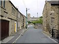
Church Lane, Wolsingham
View north towards Image Rectory Lane is ahead, on the right.
Image: © Andrew Curtis
Taken: 2 Sep 2011
0.00 miles
2
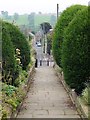
Church Lane, Wolsingham
View south from the porch of the church Image
The gate piers at the churchyard entrance, retaining walls within the churchyard, and gates are all listed buildings.
National Heritage List for England Entry Number: 1232663 https://www.historicengland.org.uk/listing/the-list/list-entry/1232663
Image: © Andrew Curtis
Taken: 2 Sep 2011
0.02 miles
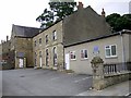
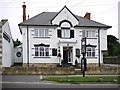
3
Masonic Hall in the former Grammar School, Wolsingham
Image: © Humphrey Bolton
Taken: 13 Sep 2023
0.02 miles
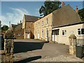
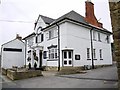
4
Church Hall and Masonic Lodge, Church Lane
These buildings are on the site of Wolsingham Grammar school. This was founded in 1614, rebuilt c1790 and enlarged in 1885.
Keys to the Past: http://www.keystothepast.info/article/10339/site-Details?PRN=D2182
Image: © Andrew Curtis
Taken: 2 Sep 2011
0.02 miles
5
In the cemetery at Wolsingham
Burial ground surrounds the Church of St. Mary and St. Stephen in Wolsingham; the area seen in this image lies to the south of the church.
Image: © Trevor Littlewood
Taken: 15 Jul 2014
0.04 miles
6
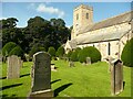
Gravestones to the south-east of the church, Wolsingham
Image: © Humphrey Bolton
Taken: 13 Sep 2023
0.04 miles
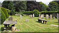
8
The former Mill Race Hotel, Wolsingham
Old photos show that at one time this was the Grey Bull Hotel. It is now operating as a bistro-style restaurant.
The 'mill race' name (also applied as a name to the street on the opposite side of the main road) is connected with a long mill race fed from a weir on the river west of the town which ran parallel to the River Wear on its north bank, powering forges and mills, including a corn mill about where the caravan site is today.
Image: © Andrew Curtis
Taken: 2 Sep 2011
0.05 miles
9
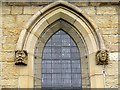
Carved heads, Wolsingham Parish Church
The sides of each window of the church Image, including those of the upper clerestory, have these 'gargoyle-type' carved heads, or more abstract plant-like designs. They were retained from inside the earlier building when it was rebuilt in the C19th and have thus been little eroded by weathering. The head on the left has quite unnerving blue-coloured eyes.
Image: © Andrew Curtis
Taken: 2 Sep 2011
0.05 miles
10
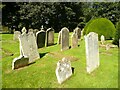
Gravestones south-west of the church, Wolsingham
Image: © Humphrey Bolton
Taken: 13 Sep 2023
0.05 miles