IMAGES TAKEN NEAR TO
Albert Terrace, BISHOP AUCKLAND, DL13 2XN
Introduction
This page details the photographs taken nearby to Albert Terrace, DL13 2XN by members of the Geograph project.
The Geograph project started in 2005 with the aim of publishing, organising and preserving representative images for every square kilometre of Great Britain, Ireland and the Isle of Man.

There are currently over 7.5m images from over14,400 individuals and you can help contribute to the project by visiting https://www.geograph.org.uk
Image Map
Images are licensed for reuse under creativecommons.org/licenses/by-sa/2.0
Notes
- Clicking on the map will re-center to the selected point.
- The higher the marker number, the further away the image location is from the centre of the postcode.
Image Listing (118 Images Found)
Images are licensed for reuse under creativecommons.org/licenses/by-sa/2.0
Image
Details
Distance
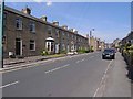
1
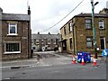
Terraces on Front Street, Stanhope
Meadow View and Albert Terrace are shown here. They are on the south side of Front Street and seem to be present on the 1898 Ordnance Survey map. So they are probably late Victorian. These are solidly built stone terraced houses.
Image: © Robert Graham
Taken: 23 Jul 2024
0.02 miles
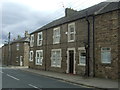
3
Front Street, Stanhope
Looking south east on the A689.
Image: © JThomas
Taken: 24 Aug 2017
0.03 miles
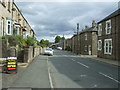
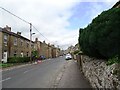
5
Albert Terrace, Stanhope
Row of houses, probably dating from mid-19th century (named presumably after Albert, Prince Consort), on the main A689 road along Weardale. Looking towards the town centre.
Image: © Oliver Dixon
Taken: 2 Jun 2009
0.03 miles
6
View along Front Street in Stanhope
Looking west towards the town centre.
Image: © Robert Graham
Taken: 23 Jul 2024
0.03 miles
8
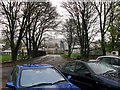
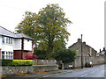
Approach to Stanhope Station
The station at Stanhope on the Weardale Railway has limited car parking. It also has a shop, cafe and toilets. The approach road shown is tree lined and curves round in front of the station.
Image: © Duncan David McColl
Taken: 1 Nov 2009
0.05 miles
9
East End (A689) (2)
Shows the location of the Image
Image: © Mike Quinn
Taken: 12 Oct 2020
0.07 miles
10
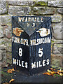
Milestone, East End (A689) / Bondisle Way
Image: © Mike Quinn
Taken: 12 Oct 2020
0.09 miles