IMAGES TAKEN NEAR TO
Frosterley, BISHOP AUCKLAND, DL13 2SY
Introduction
This page details the photographs taken nearby to DL13 2SY by members of the Geograph project.
The Geograph project started in 2005 with the aim of publishing, organising and preserving representative images for every square kilometre of Great Britain, Ireland and the Isle of Man.

There are currently over 7.5m images from over14,400 individuals and you can help contribute to the project by visiting https://www.geograph.org.uk
Image Map (Loading...)


Getting Data...Please wait
Leaflet Map data © OpenStreetMap
Images are licensed for reuse under creativecommons.org/licenses/by-sa/2.0
Notes
- Clicking on the map will re-center to the selected point.
- The higher the marker number, the further away the image location is from the centre of the postcode.
Image Listing (30 Images Found)
Images are licensed for reuse under creativecommons.org/licenses/by-sa/2.0
Image
Details
Distance
1
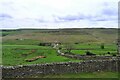
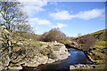
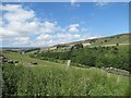
Looking into the valley of the Bollihope Burn
The Weardale Way follows the lane down to the burn, and then follows the burn down the valley to the left
Image: © Tim Heaton
Taken: 19 May 2022
0.04 miles
2
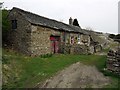
Mill Cottage south of Bollihope House
This is the only remaining building of a local complex that included Bollihope Smelt Mill which was abandoned in the 1880s http://www.beamishcollections.com/collections/display.asp?ItemID=587&MainCatID=5&SubCatID=21&SubSubCatID=&offset=17 There is a much better, recent photograph of the cottage by John Elliott here: http://www.pbase.com/jellophoto/image/54557303
Image: © Andrew Curtis
Taken: 24 Apr 2009
0.07 miles
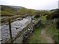
3
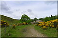
The Weardale Way approaching Mill Cottage by the Bollihope Burn
Image: © Tim Heaton
Taken: 19 May 2022
0.07 miles
4
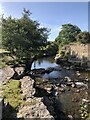
Bollihope Burn
Bollihope Burn is a tributary of the Wear. The area around the burn has been associated with metal ore mining and limestone quarrying.
Image: © David Robinson
Taken: 19 Sep 2020
0.08 miles
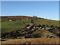
5
Bollihope Burn passing minor rocks on its north bank
The Bollihope Burn here is below Bollihope House. There's masonry remains against some of the outcropping rock and earth as if acting as a retaining wall.
Image: © Trevor Littlewood
Taken: 9 Mar 2019
0.10 miles
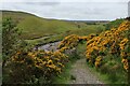
7
Bishopley, north of Bollihope Burn
The Bishopley area on the north slope of Bollihope has a number of stone built buildings but also a number of chalets and huts presumably used as weekend and holiday homes. The view here is from the slope above the south side of Bollihope Burn.
Image: © Trevor Littlewood
Taken: 13 Nov 2010
0.10 miles
10
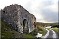
Old limekilns
Old limekilns in a quarry beside the Bollihope Burn.
Image: © Helen Wilkinson
Taken: 31 Jan 2008
0.15 miles