IMAGES TAKEN NEAR TO
Hill End, BISHOP AUCKLAND, DL13 2SU
Introduction
This page details the photographs taken nearby to Hill End, DL13 2SU by members of the Geograph project.
The Geograph project started in 2005 with the aim of publishing, organising and preserving representative images for every square kilometre of Great Britain, Ireland and the Isle of Man.

There are currently over 7.5m images from over14,400 individuals and you can help contribute to the project by visiting https://www.geograph.org.uk
Image Map (Loading...)


Getting Data...Please wait
Leaflet Map data © OpenStreetMap
Images are licensed for reuse under creativecommons.org/licenses/by-sa/2.0
Notes
- Clicking on the map will re-center to the selected point.
- The higher the marker number, the further away the image location is from the centre of the postcode.
Image Listing (33 Images Found)
Images are licensed for reuse under creativecommons.org/licenses/by-sa/2.0
Image
Details
Distance
3
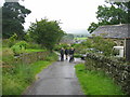
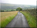
The (old) Weardale Way at Hill End
This photograph shows a view of the old route of the Weardale Way as it passed through the small village of Hill End near Frosterley. The old route used minor roads for the section between White Kirkley and Hill End (where it went off-road again). The new route (via High Bishopley) minimises the amount of road walking that has to be done on this section - but it still uses a section of road near Hill End. The picture was taken on a misty February day looking in an east-north-easterly direction towards Broadwood Quarry.
Image: © Philip Barker
Taken: 25 Feb 2010
0.04 miles

8
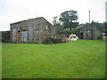
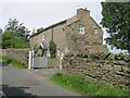
Outbuildings at Hill End
These buildings are opposite and across the road at Hill End. They were probably a coalhouse and an outside toilet (privy), possibly communal. Beyond the buildings are allotments.
Image: © Les Hull
Taken: 29 Jul 2009
0.08 miles
9
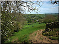
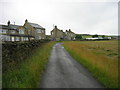
Footpath above Weardale
Frosterley down in the dale.
Image: © Karl and Ali
Taken: 23 May 2017
0.12 miles