IMAGES TAKEN NEAR TO
Frosterley, BISHOP AUCKLAND, DL13 2QE
Introduction
This page details the photographs taken nearby to DL13 2QE by members of the Geograph project.
The Geograph project started in 2005 with the aim of publishing, organising and preserving representative images for every square kilometre of Great Britain, Ireland and the Isle of Man.

There are currently over 7.5m images from over14,400 individuals and you can help contribute to the project by visiting https://www.geograph.org.uk
Image Map (Loading...)


Getting Data...Please wait
Leaflet Map data © OpenStreetMap
Images are licensed for reuse under creativecommons.org/licenses/by-sa/2.0
Notes
- Clicking on the map will re-center to the selected point.
- The higher the marker number, the further away the image location is from the centre of the postcode.
Image Listing (19 Images Found)
Images are licensed for reuse under creativecommons.org/licenses/by-sa/2.0
Image
Details
Distance
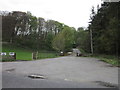
2
Rogerley Lodge
Rogerley Lodge is just off the A689 road and commands view of the Wear Valley. It does, however, face an unattractive disused quarry entrance.
Image: © William Metcalfe
Taken: 17 Jun 2007
0.03 miles
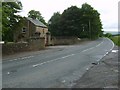
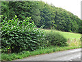
3
Woodland strip
A narrow band of woodland behind a dry stone wall to the north of the A689 road.
Image: © William Metcalfe
Taken: 17 Jun 2007
0.05 miles
4
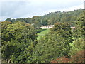
Rogerley Hall through the trees
Image: © GRAEME and LESLEY CRANSTON
Taken: 1 Oct 2006
0.06 miles
5
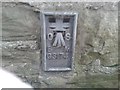
Ordnance Survey Flush Bracket G3174
This can be found on the wall of a barn in the private grounds of Rogerley Hall Lodge.
For more detail see : http://www.bench-marks.org.uk/bm12506
Image: © Peter Wood
Taken: 23 Aug 2014
0.07 miles
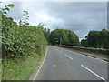
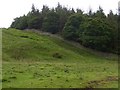
7
Farmland and woodland north of the A689 between Stanhope and Frosterley
Shows the location of the Image
Image: © Mike Quinn
Taken: 25 Aug 2022
0.12 miles
8
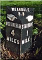
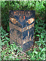
Old Milepost by the A689, north west of Frosterley
Cast iron post by the A689, in parish of STANHOPE (WEAR VALLEY District), near Rogerley Hall, Frosterley, on grass verge, hidden in hedge, on North side of road. Stanhope hands iron casting, erected by the Local Highways Board in the 19th century.
Inscription reads:- : {hand pointing right} / WOLSINGHAM / 4 / MILES : : WEARDALE / H.D : : {hand pointing left} / STANHOPE / 1 / MILE :
Milestone Society National ID: DU_WOAL04.
Image: © IA Davison
Taken: 6 Nov 2006
0.16 miles
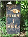
9
Milestone on the A689 between Stanhope and Frosterley
The location of this milestone is shown in Image and Image
A view of the milestone in 2006, when it was in much better condition, is shown in Image (photographed by IA Davison).
Image: © Mike Quinn
Taken: 25 Aug 2022
0.16 miles
10
Milestone on the A689 between Stanhope and Frosterley (2)
See Image
Image: © Mike Quinn
Taken: 25 Aug 2022
0.16 miles