IMAGES TAKEN NEAR TO
Stanhope, BISHOP AUCKLAND, DL13 2LN
Introduction
This page details the photographs taken nearby to DL13 2LN by members of the Geograph project.
The Geograph project started in 2005 with the aim of publishing, organising and preserving representative images for every square kilometre of Great Britain, Ireland and the Isle of Man.

There are currently over 7.5m images from over14,400 individuals and you can help contribute to the project by visiting https://www.geograph.org.uk
Image Map (Loading...)


Getting Data...Please wait
Leaflet Map data © OpenStreetMap
Images are licensed for reuse under creativecommons.org/licenses/by-sa/2.0
Notes
- Clicking on the map will re-center to the selected point.
- The higher the marker number, the further away the image location is from the centre of the postcode.
Image Listing (21 Images Found)
Images are licensed for reuse under creativecommons.org/licenses/by-sa/2.0
Image
Details
Distance
1
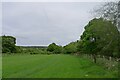
Snow Field
Isolated house on the south side of Weardale.
Image: © Oliver Dixon
Taken: 5 Nov 2008
0.02 miles
2
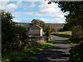
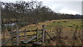
Minor road passing Snowsfield
Two roads travel the stretch of Weardale west of Stanhope; most traffic of course uses the main road, the A689, on the north side of the river. This road is on the south side of the River Wear and was photographed here passing the house at Snowsfield.
Image: © Trevor Littlewood
Taken: 20 Sep 2011
0.03 miles
3
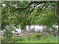
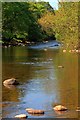
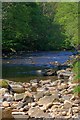
River Wear
View from the riverside path, water levels were low.
Image: © Richard Webb
Taken: 30 Jun 2008
0.13 miles
4
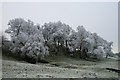
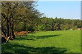
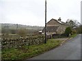
Hoar frost on Trees
A small copse of trees below Newlandside Quarry
Image: © Helen Wilkinson
Taken: 26 Dec 2006
0.15 miles