IMAGES TAKEN NEAR TO
Stanhope, BISHOP AUCKLAND, DL13 2JT
Introduction
This page details the photographs taken nearby to DL13 2JT by members of the Geograph project.
The Geograph project started in 2005 with the aim of publishing, organising and preserving representative images for every square kilometre of Great Britain, Ireland and the Isle of Man.

There are currently over 7.5m images from over14,400 individuals and you can help contribute to the project by visiting https://www.geograph.org.uk
Image Map
Images are licensed for reuse under creativecommons.org/licenses/by-sa/2.0
Notes
- Clicking on the map will re-center to the selected point.
- The higher the marker number, the further away the image location is from the centre of the postcode.
Image Listing (50 Images Found)
Images are licensed for reuse under creativecommons.org/licenses/by-sa/2.0
Image
Details
Distance
5
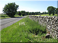
The A689 west of Stanhope
Shows the location of the Image
Image: © Mike Quinn
Taken: 25 Jun 2020
0.13 miles
6
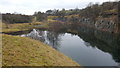
Greenfoot Quarry now disused and flooded
Image: © Clive Nicholson
Taken: 20 Jan 2017
0.13 miles
7
Greenfoot Quarry now disused and flooded
Image: © Clive Nicholson
Taken: 20 Jan 2017
0.13 miles
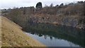
8
Greenfoot Quarry, Stanhope
A rare exposure of the Little Whin Sill, an igneous sheet of dolerite intruded into limestone rocks 300 million year ago.
Image: © Tim Heaton
Taken: 18 May 2022
0.14 miles
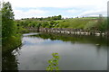
9

Greenfoot Quarry
A disused flooded limestone quarry.
Image: © Mick Garratt
Taken: 28 May 2012
0.15 miles
10
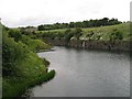
Quarry by Stanhope Bridge
Now disused and flooded.
Image: © Richard Webb
Taken: 30 Jun 2008
0.16 miles