IMAGES TAKEN NEAR TO
Rookhope, BISHOP AUCKLAND, DL13 2DG
Introduction
This page details the photographs taken nearby to DL13 2DG by members of the Geograph project.
The Geograph project started in 2005 with the aim of publishing, organising and preserving representative images for every square kilometre of Great Britain, Ireland and the Isle of Man.

There are currently over 7.5m images from over14,400 individuals and you can help contribute to the project by visiting https://www.geograph.org.uk
Image Map
Images are licensed for reuse under creativecommons.org/licenses/by-sa/2.0
Notes
- Clicking on the map will re-center to the selected point.
- The higher the marker number, the further away the image location is from the centre of the postcode.
Image Listing (14 Images Found)
Images are licensed for reuse under creativecommons.org/licenses/by-sa/2.0
Image
Details
Distance
2
Old mine shaft east of Wolf Cleugh Farm (2)
Image: © Mike Quinn
Taken: 2 Jun 2010
0.02 miles
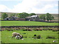
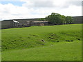
3
Wolf Cleugh Farm
View of Wolf Cleugh Farm seen from Scarsike Head.
Image: © Peter McDermott
Taken: 26 Sep 2009
0.02 miles
4
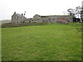
Farm at Wolf Cleugh
This photograph shows a view of an operational farm at Wolf Cleugh. The picture was taken from the public footpath that passes through the farm - looking in a southerly direction towards Walton's Allotment.
Image: © Philip Barker
Taken: 17 Oct 2010
0.02 miles
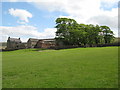
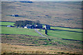
7
Farm at Wolf Cleugh
The view is over the fields surrounding the farm at Wolf Cleugh on the southern slope of the valley, Rook Hope.
Image: © Trevor Littlewood
Taken: 17 May 2016
0.03 miles
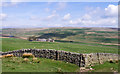
8
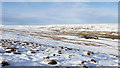
Farm buildings at Wolf Cleugh
Wolf Cleugh is an isolated farm in Rook Hope, a side valley of Weardale. The buildings lie at the centre of a number of cultivated enclosures where the snow is seen lying smoothly compared to that on the surrounding moorland.
Image: © Trevor Littlewood
Taken: 28 Jan 2012
0.03 miles
9
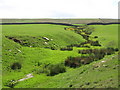
The cleugh of a minor tributary of Rookhope Burn near Wolf Cleugh Farm
Image: © Mike Quinn
Taken: 2 Jun 2010
0.11 miles