IMAGES TAKEN NEAR TO
Hylton Terrace, BISHOP AUCKLAND, DL13 2BB
Introduction
This page details the photographs taken nearby to Hylton Terrace, DL13 2BB by members of the Geograph project.
The Geograph project started in 2005 with the aim of publishing, organising and preserving representative images for every square kilometre of Great Britain, Ireland and the Isle of Man.

There are currently over 7.5m images from over14,400 individuals and you can help contribute to the project by visiting https://www.geograph.org.uk
Image Map (Loading...)


Getting Data...Please wait
Leaflet Map data © OpenStreetMap
Images are licensed for reuse under creativecommons.org/licenses/by-sa/2.0
Notes
- Clicking on the map will re-center to the selected point.
- The higher the marker number, the further away the image location is from the centre of the postcode.
Image Listing (92 Images Found)
Images are licensed for reuse under creativecommons.org/licenses/by-sa/2.0
Image
Details
Distance
3
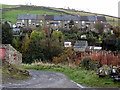
Rookhope village (2)
Almost all of the yellow fields at this time of year are buttercup meadows - but this yellow patch is Image
Image: © Mike Quinn
Taken: 23 Jun 2010
0.02 miles
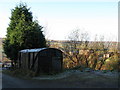
4
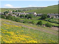
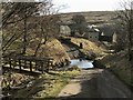
Lane leading to Hylton Terrace
The lane at the right side of the image rises steeply to reach both the named housing terrace and the Boltslaw Incline. There's a plethora of signs giving a variety of information and other 'clutter' too. The red-painted mine tub on the lawn beside the benches reflects the mining history of Rookhope village.
Image: © Trevor Littlewood
Taken: 26 Feb 2021
0.03 miles
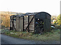
5
Old railway goods van above Bolt's Burn (2)
Image: © Mike Quinn
Taken: 29 Nov 2019
0.03 miles
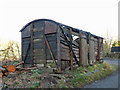
6
Old railway goods van above Bolt's Burn
The location of this old railway goods van is shown in Image Its condition has deteriorated considerably over the past 10 years - see Image taken in 2009.
Image: © Mike Quinn
Taken: 29 Nov 2019
0.03 miles
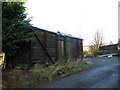
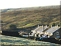
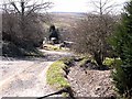
8
Old railway goods van
Appropriately enough at the foot of the Boltslaw Incline.
Image: © Mike Quinn
Taken: 9 Nov 2009
0.03 miles
9
Bolt's Burn Ford
This ford is found at Bolt's Burn near Rook Hope. A video of the ford can be seen at:
https://youtu.be/gZGAAH_NoGs
Image: © John Walton
Taken: 25 Mar 2018
0.04 miles
10
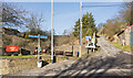
C2C at Rookhope
With a length of 225 Km, The C2C http://www.c2c-guide.co.uk/aboutc2c.htm (coast to coast) cycleway (National Cycle Network route 7) is Britain's best known cycleway and is completed by tens of thousands of cyclists every year. This shows the foot of the notorious Boltslaw Incline, looking down towards Rookhope (the ride is normally tackled in the opposite direction).
Image: © Oliver Dixon
Taken: 14 Apr 2010
0.04 miles