IMAGES TAKEN NEAR TO
Westgate, BISHOP AUCKLAND, DL13 1SW
Introduction
This page details the photographs taken nearby to DL13 1SW by members of the Geograph project.
The Geograph project started in 2005 with the aim of publishing, organising and preserving representative images for every square kilometre of Great Britain, Ireland and the Isle of Man.

There are currently over 7.5m images from over14,400 individuals and you can help contribute to the project by visiting https://www.geograph.org.uk
Image Map (Loading...)


Getting Data...Please wait
Leaflet Map data © OpenStreetMap
Images are licensed for reuse under creativecommons.org/licenses/by-sa/2.0
Notes
- Clicking on the map will re-center to the selected point.
- The higher the marker number, the further away the image location is from the centre of the postcode.
Image Listing (25 Images Found)
Images are licensed for reuse under creativecommons.org/licenses/by-sa/2.0
Image
Details
Distance
1
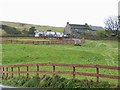
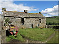
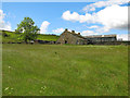
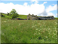
Barrasdale Farm
On the south side of Weardale.
Image: © Oliver Dixon
Taken: 5 Nov 2008
0.01 miles
2
The footpath to Field Head
Clearly not much used.
Image: © Mike Quinn
Taken: 21 Jun 2019
0.08 miles
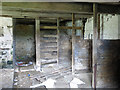
4
The site of Littlewood House
See Image Littlewood House is shown at this location on the 1923 OS map. Christine Ruskin gives records of occupation from some of the censuses from 1871 to 1911.
Image: © Mike Quinn
Taken: 20 May 2023
0.09 miles
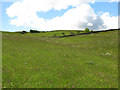
5
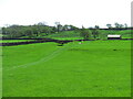
Farmland east of Field Head
Looking up towards Image
Image: © Mike Quinn
Taken: 20 May 2023
0.09 miles
8
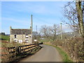
Road at Plantation House
Looking westward.
Image: © Peter Wood
Taken: 27 Mar 2017
0.11 miles