IMAGES TAKEN NEAR TO
St. Johns Chapel, BISHOP AUCKLAND, DL13 1RJ
Introduction
This page details the photographs taken nearby to DL13 1RJ by members of the Geograph project.
The Geograph project started in 2005 with the aim of publishing, organising and preserving representative images for every square kilometre of Great Britain, Ireland and the Isle of Man.

There are currently over 7.5m images from over14,400 individuals and you can help contribute to the project by visiting https://www.geograph.org.uk
Image Map
Images are licensed for reuse under creativecommons.org/licenses/by-sa/2.0
Notes
- Clicking on the map will re-center to the selected point.
- The higher the marker number, the further away the image location is from the centre of the postcode.
Image Listing (20 Images Found)
Images are licensed for reuse under creativecommons.org/licenses/by-sa/2.0
Image
Details
Distance
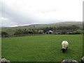
4
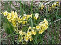
False Oxlip, St John's Chapel
The False Oxlip is a hybrid between Primrose (Primula vulgaris) & Cowslip (P. veris), also known as Primula x polyantha, or, in horticulture, Polyanthus.
True cowslips can be seen behind on the right.
Image: © Andrew Curtis
Taken: 7 May 2010
0.09 miles
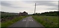
5
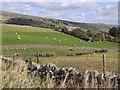
Fields at Hill Top
Just above the final steep descent to St John's Chapel.
Image: © Oliver Dixon
Taken: 23 Sep 2009
0.11 miles
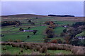
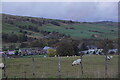
7
High Hill Top
This is advertised as an Animal Hospital
Image: © Les Hull
Taken: 7 May 2019
0.13 miles
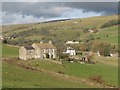
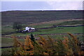
9
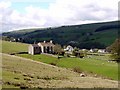
Rigg House & High Chesters, St John's Chapel
Compare the almost similar photo taken in 2007 Image
Image: © Andrew Curtis
Taken: 7 May 2010
0.15 miles
10
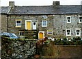
Harthopeburn Cottages.
Right next to the burn.
Image: © John Holmes
Taken: 8 May 2005
0.15 miles