IMAGES TAKEN NEAR TO
Wearhead, BISHOP AUCKLAND, DL13 1PR
Introduction
This page details the photographs taken nearby to DL13 1PR by members of the Geograph project.
The Geograph project started in 2005 with the aim of publishing, organising and preserving representative images for every square kilometre of Great Britain, Ireland and the Isle of Man.

There are currently over 7.5m images from over14,400 individuals and you can help contribute to the project by visiting https://www.geograph.org.uk
Image Map (Loading...)


Getting Data...Please wait
Leaflet Map data © OpenStreetMap
Images are licensed for reuse under creativecommons.org/licenses/by-sa/2.0
Notes
- Clicking on the map will re-center to the selected point.
- The higher the marker number, the further away the image location is from the centre of the postcode.
Image Listing (15 Images Found)
Images are licensed for reuse under creativecommons.org/licenses/by-sa/2.0
Image
Details
Distance
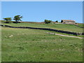
1

Upper Weardale between West Blackdene and Wearhead
Image: © Mike Quinn
Taken: 2 Nov 2018
0.03 miles
2
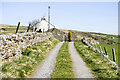
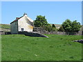
Newfield
The property at Newfield seen along its access road high on the northern side of Weardale.
Image: © Trevor Littlewood
Taken: 21 Apr 2022
0.09 miles
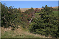
4
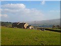
Newfield, Wearhead, Stanhope
The view over Weardale from a footpath descending from Sedling Fell.
Image: © Andrew Smith
Taken: 28 Mar 2011
0.10 miles
5
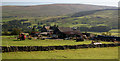
Bail Hill
Bail Hill Farm at the head of Weardale.
Image: © Peter McDermott
Taken: 26 Sep 2009
0.12 miles
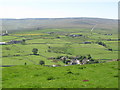
6
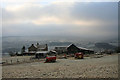
Farm and machinery
Farm overlooking Wearhead.
Image: © Helen Wilkinson
Taken: 30 Dec 2008
0.12 miles
7
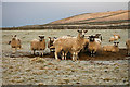
Sheep near Wearhead
Sheep congregated near their feeder waiting for silage.
Image: © Helen Wilkinson
Taken: 30 Dec 2008
0.14 miles