IMAGES TAKEN NEAR TO
Bullfield, BISHOP AUCKLAND, DL13 1JA
Introduction
This page details the photographs taken nearby to Bullfield, DL13 1JA by members of the Geograph project.
The Geograph project started in 2005 with the aim of publishing, organising and preserving representative images for every square kilometre of Great Britain, Ireland and the Isle of Man.

There are currently over 7.5m images from over14,400 individuals and you can help contribute to the project by visiting https://www.geograph.org.uk
Image Map
Images are licensed for reuse under creativecommons.org/licenses/by-sa/2.0
Notes
- Clicking on the map will re-center to the selected point.
- The higher the marker number, the further away the image location is from the centre of the postcode.
Image Listing (222 Images Found)
Images are licensed for reuse under creativecommons.org/licenses/by-sa/2.0
Image
Details
Distance
1
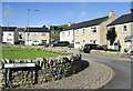
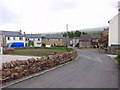
Houses on Bullfield
Bullfield is a modern development of around ten houses in the small Weardale village of Westgate.
Image: © Trevor Littlewood
Taken: 29 Sep 2021
0.01 miles
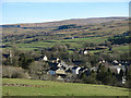
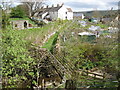
4
Westgate
View down a very steep road (from Lintzgarth in Rook Hope) to Westgate.
Image: © Richard Webb
Taken: 30 Jun 2008
0.03 miles
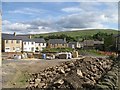
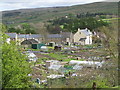
5
New houses, Westgate
Compare changes to Richard Webb's photo from 2008 Image
Image: © Andrew Curtis
Taken: 13 May 2011
0.03 miles
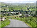
7
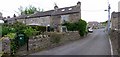
Fell View, Westgate
Former lead miners' cottages. The road on the right is Scutterhill Bank which climbs steeply over the hills to Rookhope.
Image: © Andrew Curtis
Taken: 13 May 2011
0.04 miles
8
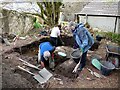
Archaeological excavation at Westgate 'Castle'
This trench on the south-east corner of the tower revealed several steps of a spiral staircase built in to the 7 foot thickness of the wall. The steps are likely to go down much further as the base of the trench is still well above the predicted ground level.
Image: © Andrew Curtis
Taken: 13 May 2011
0.06 miles
9
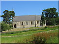
St. Andrews Church, Westgate
Keys to the Past Web Site: This church is located on a slightly elevated position north east of the village. It was built in 1867 and consecrated in 1869. It is stone built in an early English style consisting of chancel, nave, south porch with an octagonal bell turret carrying a small stone spire containing one bell.
Image: © Les Hull
Taken: 19 Jul 2006
0.06 miles
10
Footbridge over Middlehope Burn, Westgate
Image: © Mike Quinn
Taken: 2 May 2009
0.06 miles