IMAGES TAKEN NEAR TO
Front Street, BISHOP AUCKLAND, DL13 1EX
Introduction
This page details the photographs taken nearby to Front Street, DL13 1EX by members of the Geograph project.
The Geograph project started in 2005 with the aim of publishing, organising and preserving representative images for every square kilometre of Great Britain, Ireland and the Isle of Man.

There are currently over 7.5m images from over14,400 individuals and you can help contribute to the project by visiting https://www.geograph.org.uk
Image Map (Loading...)


Getting Data...Please wait
Leaflet Map data © OpenStreetMap
Images are licensed for reuse under creativecommons.org/licenses/by-sa/2.0
Notes
- Clicking on the map will re-center to the selected point.
- The higher the marker number, the further away the image location is from the centre of the postcode.
Image Listing (54 Images Found)
Images are licensed for reuse under creativecommons.org/licenses/by-sa/2.0
Image
Details
Distance
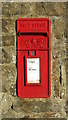
3
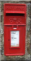
George VI postbox on Front Street, Ireshopeburn
Postbox No. DL13 135.
Image: © JThomas
Taken: 24 Aug 2017
0.09 miles
4
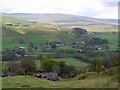
Ireshopeburn from road above New House
The road climbing out of the village becomes a track which provides access to the farm of Ireshope Plains continuing to the end of the enclosed land on the slopes of Noon Hill. Beyond the valley of Ireshope Moor, the hills rise to High Field Image Later in the day, we had this view back from the opposite side of the valley Image
Image: © Andrew Curtis
Taken: 7 May 2010
0.10 miles
5
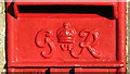
George VI postbox, Front Street, Ireshopeburn - royal cipher
See Image
Image: © Mike Quinn
Taken: 15 Nov 2018
0.10 miles
6
George VI postbox, Front Street, Ireshopeburn
The location of this postbox is shown in Image
Image: © Mike Quinn
Taken: 15 Nov 2018
0.10 miles
7
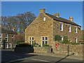
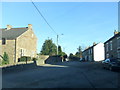
Front Street, Ireshopeburn
Shows the location of Image
Image: © Mike Quinn
Taken: 15 Nov 2018
0.10 miles
8
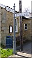
Old Direction Sign - Signpost by the A689, Ireshopeburn, Stanhope Parish
Pawn finial - 2 iron arms with finger ends; by the A689, in parish of Stanhope (Wear Valley District), Ireshopeburn, junction with Causeway Road.
Grade II listed. List Entry Number: 1231699
https://historicengland.org.uk/listing/the-list/list-entry/1231699
Surveyed
Milestone Society National ID: DU_NY8638
Image: © M Faherty
Taken: 14 May 2012
0.11 miles
9
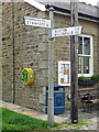
Pre-Worboys signpost, Ireshopeburn
The location of this signpost is shown in Image
Image: © Mike Quinn
Taken: 23 Jun 2022
0.11 miles
10
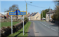
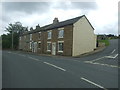
A689 entering Ireshopeburn
The A689 entering the Weardale village of Ireshopeburn from the east. The blue and yellow road sign is typical of many in County Durham.
Image: © Trevor Littlewood
Taken: 9 May 2016
0.11 miles