IMAGES TAKEN NEAR TO
West Blackdene, BISHOP AUCKLAND, DL13 1EQ
Introduction
This page details the photographs taken nearby to DL13 1EQ by members of the Geograph project.
The Geograph project started in 2005 with the aim of publishing, organising and preserving representative images for every square kilometre of Great Britain, Ireland and the Isle of Man.

There are currently over 7.5m images from over14,400 individuals and you can help contribute to the project by visiting https://www.geograph.org.uk
Image Map
Images are licensed for reuse under creativecommons.org/licenses/by-sa/2.0
Notes
- Clicking on the map will re-center to the selected point.
- The higher the marker number, the further away the image location is from the centre of the postcode.
Image Listing (64 Images Found)
Images are licensed for reuse under creativecommons.org/licenses/by-sa/2.0
Image
Details
Distance
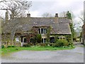
1
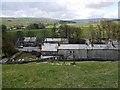
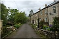
Above West Blackdene
West Blackdene is a small community on the north side of the River Wear between Ireshopeburn and Wearhead.
Image: © Andrew Curtis
Taken: 7 May 2010
0.01 miles
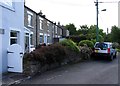
3
West Blackdene
Terraced housing seen across the road access (bridge) over the River Wear.
Image: © Trevor Littlewood
Taken: 16 Mar 2020
0.02 miles
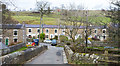
6
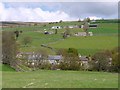
West Blackdene and Whitestones
One of the good things about walking around the valley sides in Weardale is being able to look back over the valley to where you have been. The distant cottage to the right is High Whitestones Image, below is Whitestones Farm Image, with Low Whitestones below Image
West Blackdene is the hamlet in the Wear valley. The bridge that takes the road over the dismantled railway can be seen on the left.
Life in Weardale was built on lead mining. Miners were poorly paid and relied on produce from small farms to feed their families. These are scattered along the hillside The lead mining industry finally collapsed in 1882 but many mines were reopened to extract fluorspar. The terraced houses of West Blackdene provided workers for the nearby lead mine (closed 1987), a saw mill, and later still, a fluorspar processing plant on the same site. The latter was closed in 1996. Many of the small farms belonging to miner-farmers were deserted and their cottages became derelict. Farming in the Dale became amalgamated into larger farms, such as that at Whitestones. Recent years have seen a lot of these buildings renovated providing attractive cottages for those who commute to work in nearby towns, or manage to work from home. It has, though, pushed up house prices for first-time buyers who want to stay in the community.
Image: © Andrew Curtis
Taken: 7 May 2010
0.03 miles
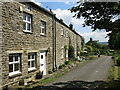
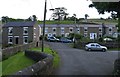
9
West Blackdene
Small community near Ireshopeburn in Weardale
Image: © Chris Heaton
Taken: 17 May 2022
0.04 miles
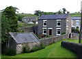
10
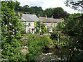
The River Wear and cottages at West Blackdene
Image: © Mike Quinn
Taken: 23 Jun 2022
0.04 miles