IMAGES TAKEN NEAR TO
Greta Bridge, BARNARD CASTLE, DL12 9SE
Introduction
This page details the photographs taken nearby to DL12 9SE by members of the Geograph project.
The Geograph project started in 2005 with the aim of publishing, organising and preserving representative images for every square kilometre of Great Britain, Ireland and the Isle of Man.

There are currently over 7.5m images from over14,400 individuals and you can help contribute to the project by visiting https://www.geograph.org.uk
Image Map
Images are licensed for reuse under creativecommons.org/licenses/by-sa/2.0
Notes
- Clicking on the map will re-center to the selected point.
- The higher the marker number, the further away the image location is from the centre of the postcode.
Image Listing (28 Images Found)
Images are licensed for reuse under creativecommons.org/licenses/by-sa/2.0
Image
Details
Distance
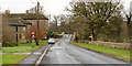
1
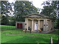
South Lodge : Rokeby Park
This south Lodge of the Rokeby Park Estate, next to Greta Bridge, is now cut off from the Park by a dual carriageway section of the A66.
Image: © Hugh Mortimer
Taken: 30 Sep 2006
0.01 miles
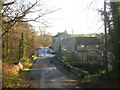
2
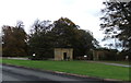
Old entrance to Rokeby Park
Before the A66 dual carriageway
Image: © David Brown
Taken: 25 Oct 2011
0.01 miles
3
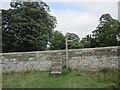
Steps up to Greta Bridge
On the footpath from Brignall.
Image: © Jonathan Thacker
Taken: 15 Aug 2018
0.04 miles
4
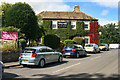
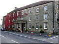
The Morritt Arms
The Morrit Arms public house and hotel at Greta Bridge.
Image: © Peter McDermott
Taken: 8 Sep 2012
0.06 miles
5

River Greta
The River Greta at Great Bridge.
Image: © Peter McDermott
Taken: 8 Sep 2012
0.06 miles
6
Greta Bridge village
A view of Greta Bridge village, the old coaching station, from the west. The road on which Greta Bridge stands has now been bypassed by a short length of dual carriageway on the A66, Scotch Corner to Penrith road.
Image: © Oliver Dixon
Taken: 12 Dec 2005
0.06 miles
7
Greta Bridge
Greta Bridge is a small settlement now on the south side of the A66. The name will derive from that of the bridge ahead in the image which is named on OS maps as Greta Bridge, printed in a gothic style text indicating that it's an antiquity. There's another Greta Bridge nearby, a modern structure carrying the A66.
Image: © Trevor Littlewood
Taken: 27 Nov 2016
0.06 miles
8
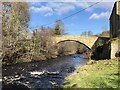
Greta Bridge
Grade II listed bridge from 1773 by John Carr. The bridge is located at an historic crossing point that once boasted three coaching inns. The earthworks of a Roman fort are adjacent on the western bank.
Image: © David Robinson
Taken: 21 Feb 2022
0.06 miles
9
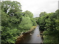
The River Greta at Greta Bridge
The modern Greta Bridge on the A66 just visible between the trees.
Image: © Jonathan Thacker
Taken: 15 Aug 2018
0.06 miles
10
Morritt Arms Hotel : Greta Bridge
The Morritt Arms (Hotel, Bar-Resuarant). This former coaching Inn stands on the old (by-passed) A66 west of the River Greta.
Image: © Hugh Mortimer
Taken: 30 Sep 2006
0.06 miles