IMAGES TAKEN NEAR TO
Bowes, BARNARD CASTLE, DL12 9LW
Introduction
This page details the photographs taken nearby to DL12 9LW by members of the Geograph project.
The Geograph project started in 2005 with the aim of publishing, organising and preserving representative images for every square kilometre of Great Britain, Ireland and the Isle of Man.

There are currently over 7.5m images from over14,400 individuals and you can help contribute to the project by visiting https://www.geograph.org.uk
Image Map
Images are licensed for reuse under creativecommons.org/licenses/by-sa/2.0
Notes
- Clicking on the map will re-center to the selected point.
- The higher the marker number, the further away the image location is from the centre of the postcode.
Image Listing (120 Images Found)
Images are licensed for reuse under creativecommons.org/licenses/by-sa/2.0
Image
Details
Distance
1
Bowes
Castle & Roman Fort on the left of the village which was originally built along the line of the main road over Stainmoor, which now bypasses this quiet village.
Image: © Matthew Hatton
Taken: 29 Mar 2015
0.02 miles
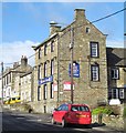
2
The Ancient Unicorn, Bowes
Coaching inn, recently re-opened and refurbished - ready for business.
This will come as a welcome relief to Pennine Way walkers, who would have no reason to take the Bowes Loop alternative with no shop or pub on offer - except perhaps for the girls.
Wainwright's guide gave 3 reasons for visiting the village. The Shop, The Inn and The Girls!
Image: © Chris Heaton
Taken: 2 Apr 2017
0.02 miles
3
![Bowes houses [4]](https://s3.geograph.org.uk/geophotos/07/33/76/7337659_4ac95847_120x120.jpg)
Bowes houses [4]
The Grove, The Street, is a large house built in the mid 18th century with late 19th century alterations. Constructed of rubble stone, squared and coursed to the front with ashlar dressings under a stone slate roof. Some original internal features remain. Listed, grade II, with details at: https://historicengland.org.uk/listing/the-list/list-entry/1159713
Bowes is a village in County Durham, some 14 miles northwest of Richmond and about 18½ miles due west of Darlington. Set on the north bank of the River Greta, the village was, until by-passed, astride the A66 trunk road. The Romans had a fort here, guarding the Stainmore pass over the Pennines, and their site was reused by the Normans who built a castle. The village grew around the castle, and the name Bowes is first mentioned in a charter of 1148.
Image: © Michael Dibb
Taken: 25 Jun 2022
0.02 miles
4
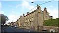
The Grove, Bowes
A mid 18thC grade 2 listed house on the main street of Bowes. A double depth structure of 3 storeys and 5 bays, but with much later bay windows inserted to the ground floor. Another of the buildings in the village which look in need of some TLC as it appears to be empty. An old Cyclists Touring Club emblem above the front door.
Image: © Gordon Hatton
Taken: 10 Mar 2015
0.03 miles
5

The Grove at Bowes
The plaque top right of the door reads, "The Cyclists' Touring Club".
Image: © David Rogers
Taken: 7 Apr 2009
0.03 miles
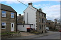
6
The Ancient Unicorn Hotel
The only pub in the village, currently closed and up for sale, so no pints available in Bowes. Once an important coaching inn on the route across Stainmoor, but now in a quiet backwater. The building is grade 2 listed, the front part visible here is of the mid 18thC. I am reliably informed that the pub has been refurbished and has reopened, which is good news for villagers and passers by [April 2016].
Image: © Gordon Hatton
Taken: 10 Mar 2015
0.04 miles
7
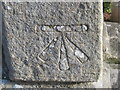
Ordnance Survey Cut Mark
This mark can be found on the wall of a house in The Street.
For more detail see : http://www.bench-marks.org.uk/bm46142
Image: © Peter Wood
Taken: 10 Nov 2012
0.04 miles
8
![Parish church [8]](https://s2.geograph.org.uk/geophotos/07/33/42/7334274_28581033_120x120.jpg)
Parish church [8]
Part of the churchyard.
The Anglican parish church of Saint Giles has a mid 12th century nave, a 13th century chancel, 14th century north and south transepts and a 15th century south porch. The church was heavily restored and a north porch added in 1863. Constructed of coursed sandstone rubble under slate roofs. The church has two fonts. One is a large 12th century stone bowl which sits on a 13th century stem which is believed to have belonged to the other font. The second font is a smaller stone bowl which stands on a base from a Roman altar. Listed, grade II, with details at: https://historicengland.org.uk/listing/the-list/list-entry/1323050
Bowes is a village in County Durham, some 14 miles northwest of Richmond and about 18½ miles due west of Darlington. Set on the north bank of the River Greta, the village was, until by-passed, astride the A66 trunk road. The Romans had a fort here, guarding the Stainmore pass over the Pennines, and their site was reused by the Normans who built a castle. The village grew around the castle, and the name Bowes is first mentioned in a charter of 1148.
Image: © Michael Dibb
Taken: 25 Jun 2022
0.05 miles