IMAGES TAKEN NEAR TO
Lartington, BARNARD CASTLE, DL12 9DD
Introduction
This page details the photographs taken nearby to DL12 9DD by members of the Geograph project.
The Geograph project started in 2005 with the aim of publishing, organising and preserving representative images for every square kilometre of Great Britain, Ireland and the Isle of Man.

There are currently over 7.5m images from over14,400 individuals and you can help contribute to the project by visiting https://www.geograph.org.uk
Image Map
Images are licensed for reuse under creativecommons.org/licenses/by-sa/2.0
Notes
- Clicking on the map will re-center to the selected point.
- The higher the marker number, the further away the image location is from the centre of the postcode.
Image Listing (32 Images Found)
Images are licensed for reuse under creativecommons.org/licenses/by-sa/2.0
Image
Details
Distance
1
![A circular walk from Barnard Castle [40]](https://s0.geograph.org.uk/geophotos/07/26/86/7268696_b69f2066_120x120.jpg)
A circular walk from Barnard Castle [40]
The Grove is a detached house in Lartington Green Lane. Built circa 1840 possibly incorporating an earlier, 18th century, house. Constructed of squared, coursed rubble stone with ashlar dressings and quoins, all under a slate roof.
Listed, grade II, with details at: https://historicengland.org.uk/listing/the-list/list-entry/1121027
The garden wall and gate piers were constructed in the mid 19th century. Listed, grade II, with details at: https://historicengland.org.uk/listing/the-list/list-entry/1310511
Image: © Michael Dibb
Taken: 18 Jun 2022
0.00 miles
2
![A circular walk from Barnard Castle [39]](https://s3.geograph.org.uk/geophotos/07/26/86/7268695_2da22a4c_120x120.jpg)
A circular walk from Barnard Castle [39]
This outbuilding in Lartington Green Lane is some 25 yards from The Grove Image It is of two builds from the early to mid 19th century. One part is of coursed rubble stone under a stone slate roof. The other part is of squared, coursed rubble stone under a Welsh slate roof. The first-floor room of the right section was used as a Methodist Chapel during the 19th and early 20th century and has a panelled wood ceiling. Listed, grade II, with details at: https://historicengland.org.uk/listing/the-list/list-entry/1121028
After crossing the River Tees, the route follows Deepdale Beck for a short distance before branching northwest to Raygill and Osmond Flatt. Then further west on a bridleway before turning north on a footpath to Lartington. After passing through the village, there is a turn to the north at Lartington Hall, then the route heads southeast past Grotto Wood and Pecknell Wood to the west bank of the river Tees, where it joins the long distance Teesdale Way to return to Barnard Castle. Just under 5½ miles.
Image: © Michael Dibb
Taken: 18 Jun 2022
0.02 miles
3
![A circular walk from Barnard Castle [41]](https://s1.geograph.org.uk/geophotos/07/26/86/7268697_7f351310_120x120.jpg)
A circular walk from Barnard Castle [41]
The Beeches is a detached house in Lartington Green Lane, built circa 1840. Constructed of coursed rubble stone under a slate roof. Listed, grade II, with details at: https://historicengland.org.uk/listing/the-list/list-entry/1160595
After crossing the River Tees, the route follows Deepdale Beck for a short distance before branching northwest to Raygill and Osmond Flatt. Then further west on a bridleway before turning north on a footpath to Lartington. After passing through the village, there is a turn to the north at Lartington Hall, then the route heads southeast past Grotto Wood and Pecknell Wood to the west bank of the river Tees, where it joins the long distance Teesdale Way to return to Barnard Castle. Just under 5½ miles.
Image: © Michael Dibb
Taken: 18 Jun 2022
0.02 miles
4
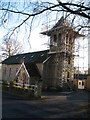
Former church at Lartington
A small village church that has been converted into a residence. Strangely there is no mention of the church in Pevsner's North Riding. [Buildings of England]
Image: © Gordon Hatton
Taken: 12 Jan 2008
0.03 miles
5
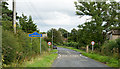
Lartington Green Lane entering Lartington
Lartington Green Lane, a minor road is entering Lartington from the west.
The blue and yellow road sign is in a style in use in County Durham for some years.
Image: © Trevor Littlewood
Taken: 30 Aug 2015
0.04 miles
6
![A circular walk from Barnard Castle [42]](https://s2.geograph.org.uk/geophotos/07/26/86/7268698_c3efebba_120x120.jpg)
A circular walk from Barnard Castle [42]
This former Roman Catholic church in Lartington Green Lane was built in the 1920s and closed in 1999. It is now a private house. Constructed of squared, coursed rubble stone with ashlar dressings under a tile roof.
After crossing the River Tees, the route follows Deepdale Beck for a short distance before branching northwest to Raygill and Osmond Flatt. Then further west on a bridleway before turning north on a footpath to Lartington. After passing through the village, there is a turn to the north at Lartington Hall, then the route heads southeast past Grotto Wood and Pecknell Wood to the west bank of the river Tees, where it joins the long distance Teesdale Way to return to Barnard Castle. Just under 5½ miles.
Image: © Michael Dibb
Taken: 18 Jun 2022
0.05 miles
8
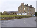
Large house at Lartington
On the B6277, now divided into flats.
Image: © Oliver Dixon
Taken: 18 Jan 2017
0.05 miles
9
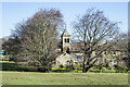
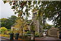
Church at Lartington
The building was the Church of St. Laurence but has been converted to a private house; it's seen from the south along the route of a field path.
Image: © Trevor Littlewood
Taken: 15 Apr 2021
0.06 miles
10
![A circular walk from Barnard Castle [43]](https://s3.geograph.org.uk/geophotos/07/26/86/7268699_2d35710a_120x120.jpg)
A circular walk from Barnard Castle [43]
Now divided into apartments, The Flatts is a large, much altered building in Lartington Lane, formerly a coaching inn. Constructed partly of squared, coursed rubble stone and partly of random rubble stone, all under a stone slate roof.
After crossing the River Tees, the route follows Deepdale Beck for a short distance before branching northwest to Raygill and Osmond Flatt. Then further west on a bridleway before turning north on a footpath to Lartington. After passing through the village, there is a turn to the north at Lartington Hall, then the route heads southeast past Grotto Wood and Pecknell Wood to the west bank of the river Tees, where it joins the long distance Teesdale Way to return to Barnard Castle. Just under 5½ miles.
Image: © Michael Dibb
Taken: 18 Jun 2022
0.06 miles