IMAGES TAKEN NEAR TO
Middle Farm, BARNARD CASTLE, DL12 8RH
Introduction
This page details the photographs taken nearby to Middle Farm, DL12 8RH by members of the Geograph project.
The Geograph project started in 2005 with the aim of publishing, organising and preserving representative images for every square kilometre of Great Britain, Ireland and the Isle of Man.

There are currently over 7.5m images from over14,400 individuals and you can help contribute to the project by visiting https://www.geograph.org.uk
Image Map
Images are licensed for reuse under creativecommons.org/licenses/by-sa/2.0
Notes
- Clicking on the map will re-center to the selected point.
- The higher the marker number, the further away the image location is from the centre of the postcode.
Image Listing (17 Images Found)
Images are licensed for reuse under creativecommons.org/licenses/by-sa/2.0
Image
Details
Distance
1
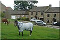
Horses in Stainton
This paddock lies between the road through the village and some modern houses. There was also a sheep in the paddock.
Image: © Graham Horn
Taken: 28 Jun 2008
0.01 miles
2
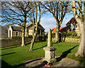
War memorial at Stainton
An attractively situated war memorial among trees on a grassed area in the village of Stainton.
The building to the right is a house; the other is the village hall.
Image: © Trevor Littlewood
Taken: 29 Dec 2015
0.03 miles
3
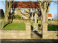
Garden area with war memorial
The war memorial in the village of Stainton is set within a small grassed area surrounded by a stone-built wall.
Image: © Trevor Littlewood
Taken: 29 Dec 2015
0.04 miles
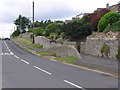
4
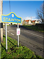
Minor road entering Stainton
As the road enters it passes a blue sign, naming the village, lettered and edged in yellow in the style typical (but not universal) in County Durham.
Image: © Trevor Littlewood
Taken: 29 Dec 2015
0.08 miles
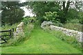
5
Stile into Stainton
This stile is effectively the entrance to the village. But the gate is private, the footpath goes to the left.
Image: © Graham Horn
Taken: 28 Jun 2008
0.10 miles
6
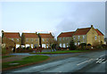
New housing in Stainton
Streatlam Close is just off the road through the village and whilst not quite the same as a single row of houses along the road, it seems like classic ribbon development nonetheless, as it extends the habitations on the north side of the road further east in a village which is already elongated east-west along a single road. Although red roofs are not typical of older properties in the area, there do seem to be quite a few others in Stainton.
Image: © Andy Waddington
Taken: 25 Nov 2009
0.11 miles
7
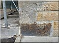
Stainton village
This property is on the north side of the road and undergoing a conversion. The benchmark is located on the south facing wall, and on the 1st stone course, and the corner stone. It is very clear.
Image: © Mel Towler
Taken: 12 Jul 2021
0.12 miles
8
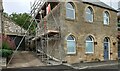
Stainton village
A wider angle showing the full face of this southern facing property in Stainton. This property is on the north side of the road and has a benchmark located on the south facing wall, and on the 1st stone course, and the corner stone. The mark is very clear.
Image: © Mel Towler
Taken: 12 Jul 2021
0.12 miles
9
Footpath in Stainton
This well kept footpath leaves the village to head behind Stainton Hill Farm. It is clean but popular with dog walkers.
Image: © Graham Horn
Taken: 28 Jun 2008
0.13 miles
10
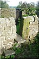
Hesley Well : Stainton
Village Well behind the wall on the right.
Image: © Hugh Mortimer
Taken: 11 Jul 2006
0.17 miles