IMAGES TAKEN NEAR TO
Demesnes, BARNARD CASTLE, DL12 8PD
Introduction
This page details the photographs taken nearby to Demesnes, DL12 8PD by members of the Geograph project.
The Geograph project started in 2005 with the aim of publishing, organising and preserving representative images for every square kilometre of Great Britain, Ireland and the Isle of Man.

There are currently over 7.5m images from over14,400 individuals and you can help contribute to the project by visiting https://www.geograph.org.uk
Image Map
Images are licensed for reuse under creativecommons.org/licenses/by-sa/2.0
Notes
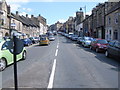
- Clicking on the map will re-center to the selected point.
- The higher the marker number, the further away the image location is from the centre of the postcode.
Image Listing (374 Images Found)
Images are licensed for reuse under creativecommons.org/licenses/by-sa/2.0
Image
Details
Distance
1
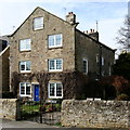
Ivy Cottage
The oldest house amidst a warren of more modern developments, Ivy Cottage faces out across the Desmesnes, a large open grassy space popular with dog walkers, just north of the River Tees.
Image: © Andy Waddington
Taken: 5 Mar 2009
0.04 miles
2
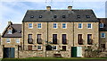
New houses facing the Desmesnes
This area is a warren of new housing developments. This is the back of a group of houses looking very neat and in character, facing out onto the big open space of Barnard Castle Desmesnes, just north of the River Tees. The properties are only let down by their remarkably scruffy back gates !
Image: © Andy Waddington
Taken: 5 Mar 2009
0.04 miles
3
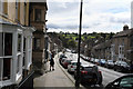
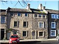
The Bank
Tanken from a little further downhill than Image
Image: © Bob Harvey
Taken: 21 Sep 2017
0.06 miles
5
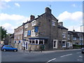
The Blue Bell pub, Bridge Gate
Image: © Nick Mutton 01329 000000
Taken: 31 May 2008
0.06 miles
6
Old properties in Thorngate
Eighteenth century cottages in Thorngate. Number 21 [with three small windows on the second storey] is described as a 'weaver's cottage', no doubt the triple windows once giving light into weaving rooms.
Image: © Gordon Hatton
Taken: 16 Nov 2017
0.06 miles
7
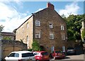
Former Broadgates Methodist Chapel, West View, Barnard Castle
Grade II Listed former Methodist Chapel dated 1764 on the west gable - this is the east gable. The blue plaque states that "This building, originally known as Broadgates Chapel, was the first Methodist Chapel to be built in Barnard Castle. Much of the labour in erecting it was undertaken by the men and women of the congregation. John Wesley preached in the opening service." There is more on the plaque but it is difficult to make out from the photograph on the Historic England website. https://historicengland.org.uk/listing/the-list/list-entry/1282876. The sign over the arch says Broadgates, which is a walkway leading across to the Bank. The building is now apartments.
Image: © Stephen Armstrong
Taken: 3 Aug 2024
0.06 miles
8
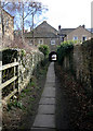
Broadgates
This tiny ginnel, entered off The Bank at NZ05011622 is called Broadgates and leads under an arched tunnel below the house seen here. There are a whole series of parallel little paths, much used by locals, but not shown on any street maps I've seen, so they are pleasantly free from tourists.
Image: © Andy Waddington
Taken: 5 Mar 2009
0.06 miles
9
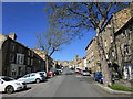
The Bank, looking towards town centre
Image: © Nick Mutton 01329 000000
Taken: 31 May 2008
0.06 miles
10
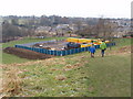
Combined Sewer Overflow works, Barnard Castle
Northumbrian Water work area on Demesnes for sewer works.
Image: © David Hawgood
Taken: 10 Jan 2009
0.06 miles