IMAGES TAKEN NEAR TO
Harwood, BARNARD CASTLE, DL12 0HT
Introduction
This page details the photographs taken nearby to DL12 0HT by members of the Geograph project.
The Geograph project started in 2005 with the aim of publishing, organising and preserving representative images for every square kilometre of Great Britain, Ireland and the Isle of Man.

There are currently over 7.5m images from over14,400 individuals and you can help contribute to the project by visiting https://www.geograph.org.uk
Image Map
Images are licensed for reuse under creativecommons.org/licenses/by-sa/2.0
Notes
- Clicking on the map will re-center to the selected point.
- The higher the marker number, the further away the image location is from the centre of the postcode.
Image Listing (18 Images Found)
Images are licensed for reuse under creativecommons.org/licenses/by-sa/2.0
Image
Details
Distance
1
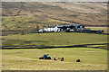
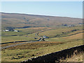
Farm at Stoney Hill
Stoney Hill is in the valley of the Harwood Beck, a tributary valley of the River Tees. It's likely that many people travelling through the valley by the B6277 heading to or from Alston believe that the river below them is the Tees; of course it isn't. The slopes of Herdship Fell are rising beyond the buildings.
Image: © Trevor Littlewood
Taken: 25 Mar 2016
0.01 miles
2
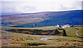
In Upper Teesdale below Grasshill Common
View SSW from B6277 Alston - Middleton-in-Teesdale road, across to West Common (Herdship Fell, 2,070 ft.), with Lune Forest (Mickle Fell, 2,591 ft.) behind on left.
Image: © Ben Brooksbank
Taken: 10 May 1965
0.06 miles
3
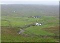
Trough Sike flows past Force Foot farm
Harwood farm beside Harwood Beck in the distance.
Image: © Russel Wills
Taken: 23 Oct 2018
0.18 miles
4
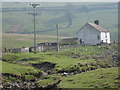
Force Foot - view NE
This photograph shows a view of the cottage at Force Foot. The picture was taken looking in a north-easterly direction towards Three Pikes. The B6277 road can just be seen running across the top of the picture between the two parallel walls.
Image: © Philip Barker
Taken: 11 May 2008
0.18 miles
5
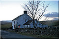
Force Foot
Force Foot, a cottage which sits between Drygill Sike and Trough Sike near their confluence with Harwood Beck. Harwood Farm is on the left and further up the valley is Herdship.
Image: © Peter McDermott
Taken: 17 Feb 2008
0.18 miles
7
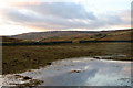
Waterlogged field at Harwood
Water ponding in the fields alongside Harwood Beck.
Image: © Helen Wilkinson
Taken: 10 Mar 2009
0.19 miles
8
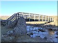
Footbridge over Harwood Beck
This substantial footbridge is constructed to stand well clear of any possible flood. Unfortunately, the paths accessed by the bridge on the north side of the beck are virtually untraceable.
Image: © Oliver Dixon
Taken: 5 Jan 2017
0.21 miles
9
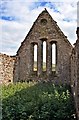
Interior View of Ruined Chapel at Harwood Beck
Image: © Paul Buckingham
Taken: 12 Sep 2007
0.21 miles
10
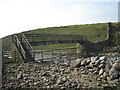
Footbridge over Harwood Beck
This photograph shows the footbridge over Harwood Beck. The picture was taken looking in a south-south-easterly direction towards High Stoney Comb.
Image: © Philip Barker
Taken: 11 May 2008
0.22 miles