IMAGES TAKEN NEAR TO
John Street, DARLINGTON, DL1 1LG
Introduction
This page details the photographs taken nearby to John Street, DL1 1LG by members of the Geograph project.
The Geograph project started in 2005 with the aim of publishing, organising and preserving representative images for every square kilometre of Great Britain, Ireland and the Isle of Man.

There are currently over 7.5m images from over14,400 individuals and you can help contribute to the project by visiting https://www.geograph.org.uk
Image Map
Images are licensed for reuse under creativecommons.org/licenses/by-sa/2.0
Notes
- Clicking on the map will re-center to the selected point.
- The higher the marker number, the further away the image location is from the centre of the postcode.
Image Listing (70 Images Found)
Images are licensed for reuse under creativecommons.org/licenses/by-sa/2.0
Image
Details
Distance
1
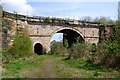
Weardale branch line bridge over the River Skerne
As the River Skerne flows into increasingly industrial landscape towards central Darlington, its banks look far less cared for than just a short way upstream. The river is confined between concrete banks and passes under the equally neglected looking bridge carrying the branch railway to North Road station, Newton Aycliffe, Shildon, Bishop Auckland and eventually into Weardale. In my youth, such a bridge would have been much used by impecunious young rock climbers, but here a lot of bramble clearing would be needed. Perhaps public transport is good enough to get to some real outcrops - or maybe computer games have suppressed the urge to adventure ?
Image: © Andy Waddington
Taken: 23 Apr 2014
0.06 miles
2
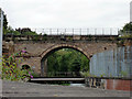
Skerne Bridge
Carries the Stockton & Darlington Railway across the River Skerne.
Image: © John Lucas
Taken: 17 Aug 2012
0.06 miles
3
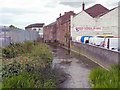
River Sterne, Darlington
The River Sterne, viewed from John Street.
Image: © David Dixon
Taken: 21 Jun 2011
0.08 miles
4
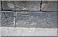
Benchmark on boundary wall of #93 High Northgate
Ordnance Survey cut mark benchmark described on the Bench Mark Database at http://www.bench-marks.org.uk/bm77272
Image: © Roger Templeman
Taken: 23 Jul 2016
0.10 miles
5
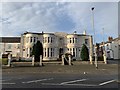
Darlington Club and Institute Limited
At the junction of High Northgate and Arthur Street.
Image: © Andrew Abbott
Taken: 30 Dec 2019
0.11 miles
6
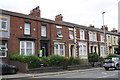
Houses on High Northgate
There is an OS benchmark Image on the stone wall in front of the houses, on the base stone left of the nearest metal gate
Image: © Roger Templeman
Taken: 23 Jul 2016
0.11 miles
7
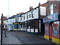
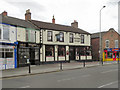
The Railway Tavern, Darlington
Situated on High Northgate, the Railway Tavern was one of the first "Railway" pubs in the world. Opened in 1827 to serve passengers of the two-year old Stockton & Darlington Railway.
Image: © JThomas
Taken: 28 Nov 2015
0.11 miles
8
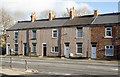
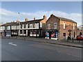
Terraced housing, High Northgate
High Northgate is the name of either the terrace of housing or that by which the A167 is known at this location, which is adjacent to Darlington's North Road Station.
Image: © Trevor Littlewood
Taken: 19 Nov 2015
0.11 miles
9
Railway Tavern, High Northgate, Darlington
Image: © David Dixon
Taken: 21 Jun 2011
0.11 miles
10
Railway Tavern, Darlington
On High Northgate.
Image: © Andrew Abbott
Taken: 30 Dec 2019
0.12 miles