IMAGES TAKEN NEAR TO
Barningham, RICHMOND, DL11 7DZ
Introduction
This page details the photographs taken nearby to DL11 7DZ by members of the Geograph project.
The Geograph project started in 2005 with the aim of publishing, organising and preserving representative images for every square kilometre of Great Britain, Ireland and the Isle of Man.

There are currently over 7.5m images from over14,400 individuals and you can help contribute to the project by visiting https://www.geograph.org.uk
Image Map
Images are licensed for reuse under creativecommons.org/licenses/by-sa/2.0
Notes
- Clicking on the map will re-center to the selected point.
- The higher the marker number, the further away the image location is from the centre of the postcode.
Image Listing (11 Images Found)
Images are licensed for reuse under creativecommons.org/licenses/by-sa/2.0
Image
Details
Distance
1
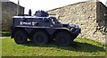
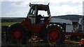
Expecting Trouble?
I was definitely not expecting to see an armoured car when I took a stroll. Parked between East Hope and Far East Hope.
Image: © Matthew Hatton
Taken: 16 Apr 2010
0.00 miles
3
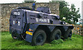
East Hope
Police vehicle at East Hope.
Image: © Peter McDermott
Taken: 8 Sep 2012
0.01 miles
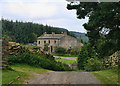
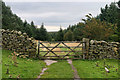
4
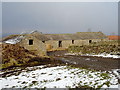
Outbuildings, East Hope
An L-shaped farm building on the north side of the minor road to East Hope, and at the western limit of the first farm encountered on that road.
Image: © Andy Waddington
Taken: 19 Feb 2010
0.03 miles
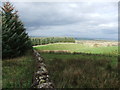
8
In Pasture Hill
The edge of Hope Plantation, part of The Stang Forest.
Image: © Peter McDermott
Taken: 8 Sep 2012
0.23 miles
9
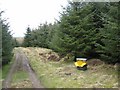
Pheasant feeder in Stang Forest
There are a number of pheasant feeders distributed around the forest.
Image: © Oliver Dixon
Taken: 13 Mar 2007
0.24 miles
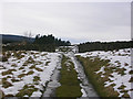
10

Autumnal larch trees beside minor road
The foreground route, a bridleway is just entering a coniferous plantation on the south side of the minor road west of the farm at East Hope. That minor road, barely discernible in the image, runs in front of the larch trees.
Image: © Trevor Littlewood
Taken: 13 Nov 2016
0.25 miles