IMAGES TAKEN NEAR TO
Clifford View, RICHMOND, DL11 7DB
Introduction
This page details the photographs taken nearby to Clifford View, DL11 7DB by members of the Geograph project.
The Geograph project started in 2005 with the aim of publishing, organising and preserving representative images for every square kilometre of Great Britain, Ireland and the Isle of Man.

There are currently over 7.5m images from over14,400 individuals and you can help contribute to the project by visiting https://www.geograph.org.uk
Image Map
Images are licensed for reuse under creativecommons.org/licenses/by-sa/2.0
Notes
- Clicking on the map will re-center to the selected point.
- The higher the marker number, the further away the image location is from the centre of the postcode.
Image Listing (14 Images Found)
Images are licensed for reuse under creativecommons.org/licenses/by-sa/2.0
Image
Details
Distance
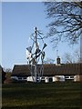
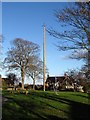
1
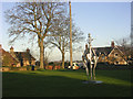
Ovington, the "Maypole Village" near Barnard Castle
A maypole has stood on the village green of Ovington for centuries. This is now commemorated with a modern metal symbolic maypole.
Image: © Oliver Dixon
Taken: 12 Dec 2005
0.14 miles
3
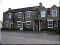
Four Alls Hotel : Ovington
FOUR ALLS: I Govern All, I Fight for All, I Pray for All, I Pay for All.
Image: © Hugh Mortimer
Taken: 5 Apr 2006
0.14 miles
6
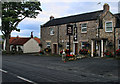
The Four Alls
The Four Alls Inn at Ovington.
Image: © Peter McDermott
Taken: 2 Sep 2011
0.15 miles
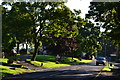
8

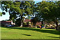
Road on north side of village green
The roughly surfaced road gives access to a few homes on the north side of the small green at the centre of the village of Ovington.
Image: © Trevor Littlewood
Taken: 18 Jan 2022
0.15 miles
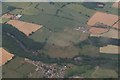
10
Ovington green and maypole
The small village of Ovington has little of note for the 'geograph' photographer, other than the maypole and the Four Alls pub. A parked 'Richmondshire' mini bus had me confused. Was I back in North Yorkshire, or is this a part of the old North Riding 'acquired' by Co Durham in 1974? Border lines marked on the map would indicate that this is indeed now administered by County Durham.
Image: © Gordon Hatton
Taken: 16 Nov 2017
0.16 miles