IMAGES TAKEN NEAR TO
Reeth, RICHMOND, DL11 6TS
Introduction
This page details the photographs taken nearby to DL11 6TS by members of the Geograph project.
The Geograph project started in 2005 with the aim of publishing, organising and preserving representative images for every square kilometre of Great Britain, Ireland and the Isle of Man.

There are currently over 7.5m images from over14,400 individuals and you can help contribute to the project by visiting https://www.geograph.org.uk
Image Map
Images are licensed for reuse under creativecommons.org/licenses/by-sa/2.0
Notes
- Clicking on the map will re-center to the selected point.
- The higher the marker number, the further away the image location is from the centre of the postcode.
Image Listing (278 Images Found)
Images are licensed for reuse under creativecommons.org/licenses/by-sa/2.0
Image
Details
Distance
2
![A circular walk from Reeth via Fremington Edge [2]](https://s1.geograph.org.uk/geophotos/07/28/02/7280249_7d34e330_120x120.jpg)
A circular walk from Reeth via Fremington Edge [2]
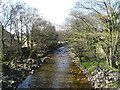
Arkle Beck, looking upstream from Reeth Bridge Image
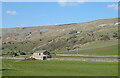
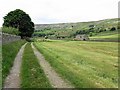
From Reeth the route climbs very steeply to run along rocky Fremington Edge on Marrick Moor. A gentler descent in the direction of Marrick village follows before turning right towards Grinton. Then along the banks of the River Swale and Arkle Beck to return to Reeth. About 4¾ miles.
Image: © Michael Dibb
Taken: 20 Jun 2022
0.04 miles
3
![A circular walk from Reeth via Fremington Edge [5]](https://s0.geograph.org.uk/geophotos/07/28/02/7280252_7ad0ff15_120x120.jpg)
A circular walk from Reeth via Fremington Edge [5]
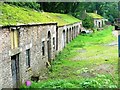
Seen from the road is this range of stables and storage buildings. Built in the late 18th or early 19th century for the AD Mining Company. Constructed of coursed rubble stone under a stone slate roof. Listed, grade II, with details at: https://historicengland.org.uk/listing/the-list/list-entry/1131500
From Reeth the route climbs very steeply to run along rocky Fremington Edge on Marrick Moor. A gentler descent in the direction of Marrick village follows before turning right towards Grinton. Then along the banks of the River Swale and Arkle Beck to return to Reeth. About 4¾ miles.
Image: © Michael Dibb
Taken: 20 Jun 2022
0.04 miles
4
![A circular walk from Reeth via Fremington Edge [6]](https://s1.geograph.org.uk/geophotos/07/28/02/7280253_5d71366f_120x120.jpg)
A circular walk from Reeth via Fremington Edge [6]
The track, a public footpath, heads up Arkengarthdale.
From Reeth the route climbs very steeply to run along rocky Fremington Edge on Marrick Moor. A gentler descent in the direction of Marrick village follows before turning right towards Grinton. Then along the banks of the River Swale and Arkle Beck to return to Reeth. About 4¾ miles.
Image: © Michael Dibb
Taken: 20 Jun 2022
0.04 miles
6
Former Mine Buildings, Reeth
See associated discussion for history of these buildings http://www.geograph.org.uk/discuss/index.php?&action=vthread&forum=5&topic=4225
Image: © Mick Garratt
Taken: 16 Sep 2006
0.05 miles
8
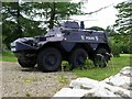
Armoured car, Reeth Bridge
Saracen Police armoured car from Hong Kong on the forecourt of Dorant 4x4 car dealership near Reeth Bridge.
http://www.scmp.com/magazines/post-magazine/article/1903597/hong-kongs-saracen-armoured-police-cars-patrol-small-town
Image: © Andrew Curtis
Taken: 12 Jun 2018
0.05 miles
9
![A circular walk from Reeth via Fremington Edge [7]](https://s2.geograph.org.uk/geophotos/07/28/02/7280254_9a86c1a7_120x120.jpg)
A circular walk from Reeth via Fremington Edge [7]
An unusual vehicle in the yard of Dorant car dealers, the former Weighill's garage.
From Reeth the route climbs very steeply to run along rocky Fremington Edge on Marrick Moor. A gentler descent in the direction of Marrick village follows before turning right towards Grinton. Then along the banks of the River Swale and Arkle Beck to return to Reeth. About 4¾ miles.
Image: © Michael Dibb
Taken: 20 Jun 2022
0.05 miles