IMAGES TAKEN NEAR TO
Arkengarthdale, RICHMOND, DL11 6RP
Introduction
This page details the photographs taken nearby to DL11 6RP by members of the Geograph project.
The Geograph project started in 2005 with the aim of publishing, organising and preserving representative images for every square kilometre of Great Britain, Ireland and the Isle of Man.

There are currently over 7.5m images from over14,400 individuals and you can help contribute to the project by visiting https://www.geograph.org.uk
Image Map
Images are licensed for reuse under creativecommons.org/licenses/by-sa/2.0
Notes
- Clicking on the map will re-center to the selected point.
- The higher the marker number, the further away the image location is from the centre of the postcode.
Image Listing (13 Images Found)
Images are licensed for reuse under creativecommons.org/licenses/by-sa/2.0
Image
Details
Distance
2
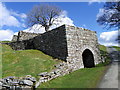
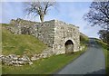
Limekiln, Low Sealhouse Farm
In the 18th and 19th centuries, when lime was extensively used on acid clay soil to improve cultivation, lime kilns were widespread. Beehive shaped, with a hole in the top, kilns were usually built on the sides of steep hills and against cliff faces, to make the loading of limestone and coal easier. Alternating layers of limestone and coal were burnt to produce the lime.
This kiln dates from the early 19th century.
Image: © Maigheach-gheal
Taken: 3 Apr 2011
0.10 miles
3
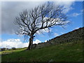
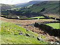
Drystone wall near Whaw
Drystone walls are built without mortar, and their stability – they can stand for 200 years – is due to the skill of the craftsmen who place rough boulders and angular stones together.
Many drystone walls were constructed as part of the enclosure of open grazing. They were especially useful in areas too exposed for hedgerows to survive and where stones were readily available.
Most drystone walls are wider at the base than at the crown, and are often capped with coping stones. A typical wall has two outer layers of large, flattish stones enclosing an inner ‘heart’ of smaller, rounder stones. Often it is reinforced with ‘through bands’ of even larger, flat stones which can also be used as stiles.
The very dryness of a wall makes it more likely to endure wind and frost and to act as shelter for livestock as well as a boundary.
The tree appears to be hanging on to life as well.
Image: © Maigheach-gheal
Taken: 3 Apr 2011
0.10 miles
5
Road and limekiln, Seal Houses
A well preserved limekiln at the roadside at Seal Houses above Whaw in Arkengarthdale.
Image: © Gordon Hatton
Taken: 20 Nov 2010
0.14 miles
6
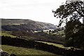
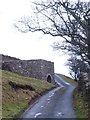
Whaw
Whaw is the last community near the head of Arkengarthdale.
Image: © Gordon Hatton
Taken: Unknown
0.14 miles
7
Drystone walls near Whaw
The valley is criss-crossed with drystone walls.
Drystone walls are built without mortar, and their stability – they can stand for 200 years – is due to the skill of the craftsmen who place rough boulders and angular stones together.
Many drystone walls were constructed as part of the enclosure of open grazing. They were especially useful in areas too exposed for hedgerows to survive and where stones were readily available.
Most drystone walls are wider at the base than at the crown, and are often capped with coping stones. A typical wall has two outer layers of large, flattish stones enclosing an inner ‘heart’ of smaller, rounder stones. Often it is reinforced with ‘through bands’ of even larger, flat stones which can also be used as stiles.
The very dryness of a wall makes it more likely to endure wind and frost and to act as shelter for livestock as well as a boundary.
Image: © Maigheach-gheal
Taken: 3 Apr 2011
0.15 miles
8
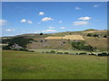
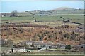
Whaw Scars and fields around Seal Houses
Mixture of bedrock and glacial action has left behind scars along the valley side.
The bedrock varies from Five Yard Limestone near the top of the scars to Argillaceous Bioclastic limestones, sandstones, mudstones, siltstones and rare coals. This area has been worked by man in the 18th & 19th centuries for building stone and lime for the land.
Image: © Matthew Hatton
Taken: 6 Jul 2018
0.19 miles