IMAGES TAKEN NEAR TO
Arkengarthdale, RICHMOND, DL11 6HA
Introduction
This page details the photographs taken nearby to DL11 6HA by members of the Geograph project.
The Geograph project started in 2005 with the aim of publishing, organising and preserving representative images for every square kilometre of Great Britain, Ireland and the Isle of Man.

There are currently over 7.5m images from over14,400 individuals and you can help contribute to the project by visiting https://www.geograph.org.uk
Image Map
Images are licensed for reuse under creativecommons.org/licenses/by-sa/2.0
Notes
- Clicking on the map will re-center to the selected point.
- The higher the marker number, the further away the image location is from the centre of the postcode.
Image Listing (26 Images Found)
Images are licensed for reuse under creativecommons.org/licenses/by-sa/2.0
Image
Details
Distance
2
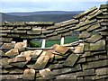
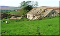
Dilapidated Barn Roof on Windegg Lane.
The same barn as Image above Arkengarthdale.
Image: © Steve Partridge
Taken: 7 May 2007
0.08 miles
3
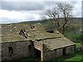
Dilapidated Barn on Windegg Lane.
The same barn as Image
Image: © Steve Partridge
Taken: 7 May 2007
0.08 miles
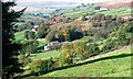
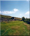
4
Scarhouse Lane
This photograph shows a view of a section of Scarhouse Lane (a track) which runs between Stang Lane (to the right) and Scar House (to the left). The section of track depicted in this image runs along the near-side of the stone wall seen in the foreground of the picture. Stang Lane (walled) can be seen in the right-hand side of the image The picture was taken looking in a west-south-westerly direction towards Great Pinseat.
Image: © Philip Barker
Taken: 26 Sep 2010
0.11 miles
5
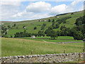
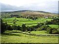
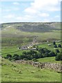
Arkengarthdale
View across the dale from the CB Inn beer garden. Arkle Beck runs through the dale.
Image: © Pauline E
Taken: 24 Jul 2011
0.12 miles
7
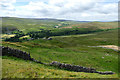
Looking down from the Windegg Scar bridleway
The bridleway follows a good Landrover track just below Windegg Scar, and as the Valley of Shaw Beck drops away into Arkengarthdale, excellent views up the dale open up. The expanse of bare stones on the right of the photo is a mine waste tip from nineteenth century lead working on the Freemans Vein above. The woodland beyond Stang Lane is Eskeleth Wood, which shows promise of being bigger in the future as there is quite a lot of new planting in tree shelters in the valley upstream. On the far horizon are Rogans Seat and Water Crag, within a few metres of the same height on Gunnerside and Arkengarthdale Moors.
Image: © Andy Waddington
Taken: 19 Jul 2020
0.13 miles
8
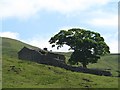
Ruined farm house on the fellside
One of several such ruins in Arkengarthdale. This one is unnamed on old 6" maps, but seems typical of the type once lived in by lead miners and families. It has often been said that lead miners were also part time farmers [the reverse is also true], with much of the farming done during the summer and the mining through the winter, neither occupation usually earning enough on its own. Update - July 2022.. the house is known as Carter's Cottage and has recently been on the market for £190,000 along with nearly 55 acres of land, but it might take more than a lick of paint and new window frames to put it right, and how do you get to it in a vehicle?
Image: © Gordon Hatton
Taken: 7 Jun 2018
0.13 miles
9
Wall side at Hill Side
On the line of a not very obvious bridleway which hugs the wall side here. Hill Side is the name given to this area on the edge of the moor, where there was once a scattering of cottages, mostly inhabited by lead miners and their families. The view across Arkengarthdale is towards the CB Yard where some buildings associated with the long gone lead industry have been converted into cottages. Beyond this can be seen the remains of the double flue that ascended the hillside from the two smelt mills that once stood here.
Image: © Gordon Hatton
Taken: 7 Jun 2018
0.13 miles
10
Windegg Arkengarthdale.
A pleasant green track high above Arkle Beck.
Image: © Gordon Hatton
Taken: Unknown
0.15 miles