IMAGES TAKEN NEAR TO
Booze, Arkengarthdale, RICHMOND, DL11 6EY
Introduction
This page details the photographs taken nearby to DL11 6EY by members of the Geograph project.
The Geograph project started in 2005 with the aim of publishing, organising and preserving representative images for every square kilometre of Great Britain, Ireland and the Isle of Man.

There are currently over 7.5m images from over14,400 individuals and you can help contribute to the project by visiting https://www.geograph.org.uk
Image Map
Images are licensed for reuse under creativecommons.org/licenses/by-sa/2.0
Notes
- Clicking on the map will re-center to the selected point.
- The higher the marker number, the further away the image location is from the centre of the postcode.
Image Listing (20 Images Found)
Images are licensed for reuse under creativecommons.org/licenses/by-sa/2.0
Image
Details
Distance
1
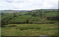
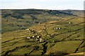
Booze from Fell End Hush
Looking across Slei Gill to the hamlet of Booze, and not a pub to be seen! The origin of the name 'Booze' is from 'boga' and 'hus' - a mixture of old English and Norse, meaning the house on the curve of the hill. In 1473 it was called 'Bowehous'.
Image: © Gordon Hatton
Taken: 1 Nov 2008
0.01 miles
2
Booze from Fell End
A zoom shot of the hamlet from the large cairn on Fell End. There is no pub in Booze - the unusual name comes from the Old Norse for a farm and has the same derivation as Bootle, Boot and Booth.
Image: © Karl and Ali
Taken: 5 May 2017
0.02 miles
5
A view of Booze
Despite the rather enticing name of this hamlet, no hostelries or dens of iniquity will be found here. Booze is derived from 'Bowehous', a mix of old English and Norse, meaning the house on the curve of the hill - which is an apt description.
Image: © Gordon Hatton
Taken: 17 Jul 2018
0.04 miles
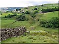
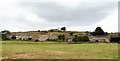
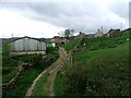
6
Properties in Booze
A number of houses in the splendidly named village at Booze seen beyond a gateway beside a path descending towards Storthwaite Hall.
Image: © Trevor Littlewood
Taken: 18 Nov 2019
0.04 miles
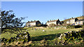
7
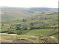
Booze
At the height of the lead mining activities in the middle of the nineteenth century there were over two hundred inhabitants in Booze. There are now just a handful with several houses in ruins. The hamlet is only accessible by a very steep road and was only connected to mains electricity in the 1960s. The name Booze probably means 'the house by the bend'.
Image: © Mick Garratt
Taken: 24 Oct 2006
0.04 miles
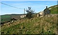
8
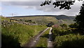
The Road to Booze
The road to the delightfully named settlement at Booze climbs steeply from Langthwaite in Arkengarthdale before reaching this level stretch. The road is so narrow and steep in places that at one time recently there was a move by the Post Office to discontinue deliveries of mail; the threat must have passed for a PO. van was seen on the road shortly before this image was recorded.
Image: © Trevor Littlewood
Taken: 16 Aug 2010
0.04 miles
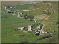
9
Booze.
Booze (Norse for 'the house on the curved hillside') is now just a cluster of farm buildings, but was once a thriving mining community with more than 40 houses.
Image: © Steve Partridge
Taken: 7 May 2007
0.04 miles