IMAGES TAKEN NEAR TO
Arkengarthdale, RICHMOND, DL11 6EJ
Introduction
This page details the photographs taken nearby to DL11 6EJ by members of the Geograph project.
The Geograph project started in 2005 with the aim of publishing, organising and preserving representative images for every square kilometre of Great Britain, Ireland and the Isle of Man.

There are currently over 7.5m images from over14,400 individuals and you can help contribute to the project by visiting https://www.geograph.org.uk
Image Map
Images are licensed for reuse under creativecommons.org/licenses/by-sa/2.0
Notes
- Clicking on the map will re-center to the selected point.
- The higher the marker number, the further away the image location is from the centre of the postcode.
Image Listing (110 Images Found)
Images are licensed for reuse under creativecommons.org/licenses/by-sa/2.0
Image
Details
Distance
1
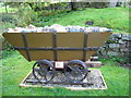
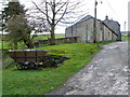
Ore Truck, Langthwaite.
A memorial to the Lead mining industry in Arkengarthdale.
Image: © David Seale
Taken: 1 Oct 2007
0.01 miles
2
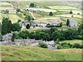
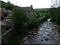
Looking down on Langthwaite
A cluster of grey cottages either side of Arkle Beck seen from the road to Booze.
Image: © Gordon Hatton
Taken: 17 Jul 2018
0.03 miles
3
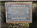
Sign, Langthwaite
The sign is on the horse wagon in Image
Image: © Maigheach-gheal
Taken: 3 Apr 2011
0.03 miles
4
Langthwaite
Approaching the village from the footpath from Scar House.
Image: © Mick Garratt
Taken: 24 Oct 2006
0.03 miles
5
Former Sunday School, Langthwaite
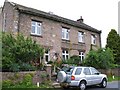
The inscription on the front of the building reads 'Wesleyan Sunday School and Institute 1923'. The building is a few metres along the road from the Wesleyan Chapel, but one wonders why such a large building was erected in 1923, long after the demise of the local lead mining industry and when the Arkengarthdale population was already in decline. Now in use as a private residence.
Image: © Gordon Hatton
Taken: 28 Jul 2010
0.03 miles
6
The Arkle Beck at Langthwaite.
Looking downstream from the Booze road.
Image: © Steve Partridge
Taken: 7 May 2007
0.04 miles
7
Bridleway, Langthwaite
The bridleway passes beside a horse wagon, a reminder of the area's mining industry.
Image: © Maigheach-gheal
Taken: 3 Apr 2011
0.04 miles
8
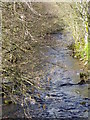
Arkle Beck, Langthwaite
Looking upstream.
Image: © Maigheach-gheal
Taken: 3 Apr 2011
0.05 miles
9
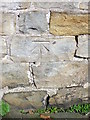
Bench Mark, No 2 Bridge End
The bench mark is to be found on the south face of the building. For a view of the building Image and for further information on the bench mark and others in the area http://www.bench-marks.org.uk/bm37867
Image: © Maigheach-gheal
Taken: 3 Apr 2011
0.05 miles
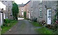
10
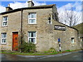
No 2 Bridge End, Langthwaite
There is an Ordnance Survey bench mark to the left of the door.
Image: © Maigheach-gheal
Taken: 3 Apr 2011
0.05 miles