IMAGES TAKEN NEAR TO
Skeugh Head Lane, RICHMOND, DL11 6DU
Introduction
This page details the photographs taken nearby to Skeugh Head Lane, DL11 6DU by members of the Geograph project.
The Geograph project started in 2005 with the aim of publishing, organising and preserving representative images for every square kilometre of Great Britain, Ireland and the Isle of Man.

There are currently over 7.5m images from over14,400 individuals and you can help contribute to the project by visiting https://www.geograph.org.uk
Image Map
Images are licensed for reuse under creativecommons.org/licenses/by-sa/2.0
Notes
- Clicking on the map will re-center to the selected point.
- The higher the marker number, the further away the image location is from the centre of the postcode.
Image Listing (13 Images Found)
Images are licensed for reuse under creativecommons.org/licenses/by-sa/2.0
Image
Details
Distance
1
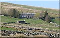
Swaledale House
Above Angram looking down on Thwaite.
Image: © Russel Wills
Taken: 10 Apr 2019
0.17 miles
3
Country south of Angram
Seen from the B6270.
Image: © David Purchase
Taken: 5 Jun 2014
0.19 miles
4
The Skeb Skeugh valley near Angram
The Skeb Skeugh valley has a tiny 'misfit' stream flowing through it today, but at some point during the last ice age, the Swale must have come this way before it carved a new course around the other side of Kisdon Hill.
Image: © Gordon Hatton
Taken: Unknown
0.21 miles
5
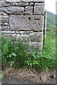
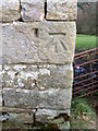
Benchmark on barn on east side of Angram Lane north of Skeugh Gill
Ordnance Survey cut mark benchmark described on the Bench Mark Database at http://www.bench-marks.org.uk/bm37904
Image: © Roger Templeman
Taken: 13 Jun 2016
0.22 miles
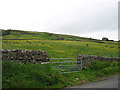
6
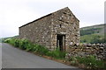
Barn beside Angram Lane north of Skeugh Gill
There is an OS benchmark Image on the near corner, road face, of the barn, 4th quoin above ground
Image: © Roger Templeman
Taken: 13 Jun 2016
0.22 miles
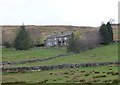
7
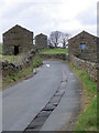
Yorkshire barns, Angram
Stone built barns beside the road through the village.
Image: © Maigheach-gheal
Taken: 3 Apr 2011
0.22 miles
8
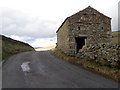
Yorkshire barn, Angram
The barn has an Ordnance Survey bench mark on the south west angle of the building.
Image: © Maigheach-gheal
Taken: 3 Apr 2011
0.22 miles
9
Bench Mark, Angram
The bench mark is to be found on the south west angle of the building. For a wider view of the building Image and for further information on the bench mark and other in the area http://www.bench-marks.org.uk/bm37904
Image: © Maigheach-gheal
Taken: 3 Apr 2011
0.22 miles
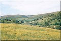
10

Skeugh Head
Just south of Angram, looking south
Image: © David Oxtaby
Taken: 1 Oct 2005
0.22 miles