IMAGES TAKEN NEAR TO
Reeth Road, RICHMOND, DL11 6AA
Introduction
This page details the photographs taken nearby to Reeth Road, DL11 6AA by members of the Geograph project.
The Geograph project started in 2005 with the aim of publishing, organising and preserving representative images for every square kilometre of Great Britain, Ireland and the Isle of Man.

There are currently over 7.5m images from over14,400 individuals and you can help contribute to the project by visiting https://www.geograph.org.uk
Image Map
Images are licensed for reuse under creativecommons.org/licenses/by-sa/2.0
Notes
- Clicking on the map will re-center to the selected point.
- The higher the marker number, the further away the image location is from the centre of the postcode.
Image Listing (8 Images Found)
Images are licensed for reuse under creativecommons.org/licenses/by-sa/2.0
Image
Details
Distance
1
Thorpe under Stone
The farm buildings of Thorpe under Stone lie within the military training area, but apart from odd warning signs round the periphery, there's nothing much to distinguish this from ordinary farmland and the sheep graze freely without being blown up. A public footpath descends from the Hudswell road to the main road in Swaledale, but as there are no continuations on the other sides of either road, it does not really form part of a longer walk, and seems little used. On the other hand, signposts invite one to traverse branch paths off both sides of the right of way marked on the map, despite signs at the roadheads advising walkers to stick to the public footpath.
Image: © Andy Waddington
Taken: 7 Jun 2021
0.00 miles
2
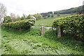
Former gateway to field on north side of A6108
There is an OS benchmark Image on the road face of the right hand gatepost
Image: © Roger Templeman
Taken: 27 May 2016
0.23 miles
3
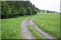
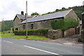
Farm track passing woodland at Thorpe House
Image: © Roger Templeman
Taken: 27 May 2016
0.24 miles
5
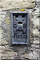
Benchmark on Thorpe House Farm
Ordnance Survey flush bracket (serial number 11589) benchmark described on the Bench Mark Database at http://www.bench-marks.org.uk/bm10854
Image: © Roger Templeman
Taken: 27 May 2016
0.24 miles
6
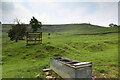
Trough and new shade tree
The public footpath from the Hudswell road down to the main road in Swaledale seems little used by walkers (there are no continuing paths the other side of either road, so it's not really part of a longer walk) and is quite faint. The trough may not be right on the right of way, but in this weather, dogs get thirsty too, and it's the only spot for a drink. Sheep need shade as well as water, and there are several recently planted trees which will provide shade as they grow. Since Oak and Ash leaf out quite late, it has been traditional to use Sycamore for shade, despite its being an ugly, invasive, non-native species. These, however, are Horse Chestnut, also non-native, but currently considered to be under threat in the UK, so planting seems to be fashionable - they certainly meet the need as providers of shade and produce better autumn colour.
Image: © Andy Waddington
Taken: 7 Jun 2021
0.24 miles
8
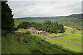
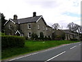
Thorpe House Farm
There is an OS benchmark Image on the near corner of the large barn, on the wall above the access track
Image: © Roger Templeman
Taken: 27 May 2016
0.25 miles