IMAGES TAKEN NEAR TO
Citadilla Close, Gatherley Road, RICHMOND, DL10 7JE
Introduction
This page details the photographs taken nearby to Citadilla Close, Gatherley Road, DL10 7JE by members of the Geograph project.
The Geograph project started in 2005 with the aim of publishing, organising and preserving representative images for every square kilometre of Great Britain, Ireland and the Isle of Man.

There are currently over 7.5m images from over14,400 individuals and you can help contribute to the project by visiting https://www.geograph.org.uk
Image Map
Images are licensed for reuse under creativecommons.org/licenses/by-sa/2.0
Notes
- Clicking on the map will re-center to the selected point.
- The higher the marker number, the further away the image location is from the centre of the postcode.
Image Listing (11 Images Found)
Images are licensed for reuse under creativecommons.org/licenses/by-sa/2.0
Image
Details
Distance
1
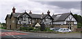
The Tudor Hotel
North of Catterick Bridge on the old A1.
Image: © Hugh Mortimer
Taken: 6 Aug 2006
0.07 miles
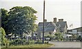
2
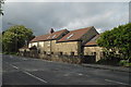
The Tudor Hotel
Not a hotel or public house for some years. Now home to a CCTV business.
Image: © Tony Simms
Taken: 22 May 2015
0.07 miles
3

Catterick Bridge railway station (site), Yorkshire
Opened in 1846 by the York & Newcastle Railway, later part of the North Eastern Railway, on the line from Eryholme Junction to Richmond (Yorkshire), this station closed to passengers in 1969 and completely in 1970.
View west across the former level crossing towards Richmond. We would have been stood on the railway track which crossed the road, to the left of the street lamp and through the low wall. The station site is now mostly covered by the modern building.
For more information, see http://www.disused-stations.org.uk/c/catterick_bridge/index.shtml
Image: © Nigel Thompson
Taken: 21 Jan 2019
0.09 miles
4
Path beside the A6136, Brompton-on-Swale
Looking north.
Image: © JThomas
Taken: 14 Nov 2015
0.09 miles
5
Catterick Bridge station (remains), 1988
View westward, towards Richmond: ex-NER (Darlington) - Eryholme Junction - Richmond line. The station, also the Catterick Military Railway which branched off to the SW, served the vast Military Camp - the largest of the British Army, with 12,000 men - and therefore important, even after World War Two, the branch seeing regular Troop and Leave trains. However, it and the line to Richmond were closed to passengers from 3/3/1969 and to goods from 9/2/1970. The track, now a roadway, was lifted in October 1970 (the Goods Yard was the scene of a major explosion of ammunition in February 1944).
Image: © Ben Brooksbank
Taken: 23 Jun 1988
0.10 miles
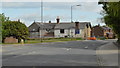
6
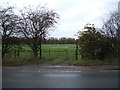
Entrance to Stephenson Road from the A6136
Image: © Peter Robinson
Taken: 8 Sep 2013
0.11 miles
7
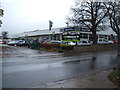
Car dealership, Brompton-on-Swale
Off the A6136.
Image: © JThomas
Taken: 14 Nov 2015
0.11 miles
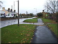
10
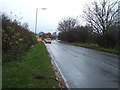
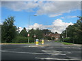
Approaching traffic lights on the B6271, Brompton-on-Swale
Heading west.
Image: © JThomas
Taken: 14 Nov 2015
0.19 miles