IMAGES TAKEN NEAR TO
Moulton Road, RICHMOND, DL10 6RJ
Introduction
This page details the photographs taken nearby to Moulton Road, DL10 6RJ by members of the Geograph project.
The Geograph project started in 2005 with the aim of publishing, organising and preserving representative images for every square kilometre of Great Britain, Ireland and the Isle of Man.

There are currently over 7.5m images from over14,400 individuals and you can help contribute to the project by visiting https://www.geograph.org.uk
Image Map
Images are licensed for reuse under creativecommons.org/licenses/by-sa/2.0
Notes
- Clicking on the map will re-center to the selected point.
- The higher the marker number, the further away the image location is from the centre of the postcode.
Image Listing (43 Images Found)
Images are licensed for reuse under creativecommons.org/licenses/by-sa/2.0
Image
Details
Distance
1

Old mine shaft in a field
There are several such bowl shaped shafts close to the parish church at Middleton Tyas. They are remnants of a short lived copper mining boom that lasted barely 40 years in the mid 18th century. Further west in Swaledale one expects to see remains of the lead mining industry, but east of Marrick towards Hudswell and Richmond lead dies out to be replaced by copper which appears along faults in the underlying carboniferous rocks. These rocks extend as far east as Middleton Tyas, and although the copper ore found here was of high quality, there wasn't much of it, thus the short period of extraction. Beyond the shaft in the picture there appears to be a grassed over spoil heap.
Image: © Gordon Hatton
Taken: 6 May 2021
0.05 miles
2
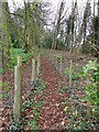
Footpath, Middleton Tyas
The enclosed footpath heads through woodland as it makes its way towards the village centre.
Image: © Maigheach-gheal
Taken: 4 Apr 2011
0.08 miles
3
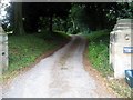
Private road leading to Wellington Lodge and the Vicarage
At Middleton Tyas.
Image: © James Denham
Taken: 29 Jul 2014
0.09 miles
4

Village sign, Middleton Tyas
The first part of the name is Anglo-Saxon and means middle farm. Tyas is a Norman French name but there is no written evidence that the place once belonged to a family of that name.
Image: © Maigheach-gheal
Taken: 4 Apr 2011
0.09 miles
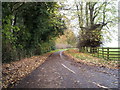
6
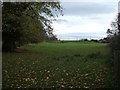
Heading south from Middleton Tyas
Towards Moulton.
Image: © JThomas
Taken: 14 Nov 2015
0.10 miles
7

Old mine workings at Middleton Tyas
The bowl shaped mound in the foreground marks the site of an old shaft into a copper mine dating back to the mid 18th century when a rich vein of copper ore was discovered here. The ore was high quality but soon worked out, so the mines lasted no more than about 40 years.
Image: © Gordon Hatton
Taken: 6 May 2021
0.11 miles
8
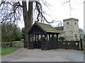
Lych gate, Church of St Michaels and All Angels
Many churches have a lych gate built over the main entrance to the enclosed area round the church. The name, also spelt lich or lytch, is from the Anglo Saxon 'lich' meaning corpse. The gate marks the division between consecrated and unconsecrated ground, where the bearers sheltered with the coffin, waiting for the clergyman to lead the procession before the burial. The original lych gates had seats, a lych cross and a lych stone - a slab on which the coffin rested.
Image: © Maigheach-gheal
Taken: 4 Apr 2011
0.12 miles
9
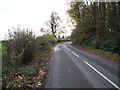
Road towards St Michael and All Angels Church, Middleton Tyas
Image: © JThomas
Taken: 14 Nov 2015
0.13 miles
10

Churchyard, Church of St Michael's and All Angels
The churchyard is large and well kept. A pheasant wandered between the daffodils at the time of my visit.
Image: © Maigheach-gheal
Taken: 4 Apr 2011
0.13 miles