IMAGES TAKEN NEAR TO
Barton, RICHMOND, DL10 6HR
Introduction
This page details the photographs taken nearby to DL10 6HR by members of the Geograph project.
The Geograph project started in 2005 with the aim of publishing, organising and preserving representative images for every square kilometre of Great Britain, Ireland and the Isle of Man.

There are currently over 7.5m images from over14,400 individuals and you can help contribute to the project by visiting https://www.geograph.org.uk
Image Map
Images are licensed for reuse under creativecommons.org/licenses/by-sa/2.0
Notes
- Clicking on the map will re-center to the selected point.
- The higher the marker number, the further away the image location is from the centre of the postcode.
Image Listing (8 Images Found)
Images are licensed for reuse under creativecommons.org/licenses/by-sa/2.0
Image
Details
Distance
1
Willow Cottage
On Croft to Barton road.
Image: © Stanley Howe
Taken: 14 Aug 2010
0.03 miles
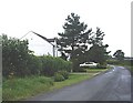
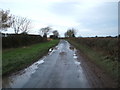
2
The back road from Middleton Tyas to Barton, North Yorkshire
Image: © Oliver Dixon
Taken: 19 Dec 2005
0.05 miles
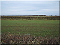
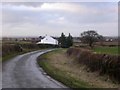
5
Minor road towards Barton
Heading north west.
Image: © JThomas
Taken: 14 Nov 2015
0.17 miles
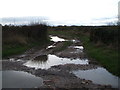
6
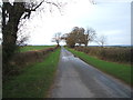
Minor road towards Barton
Heading north west.
Image: © JThomas
Taken: 14 Nov 2015
0.21 miles
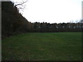
7
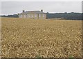
A distant view of Middleton Lodge
From the Croft to Barton road. Set in 250 acres of North Yorkshire country parkland, it was built in 1780 by architect John Carr of York.
Image: © Stanley Howe
Taken: 14 Aug 2010
0.23 miles