IMAGES TAKEN NEAR TO
Rowan Brook, RICHMOND, DL10 6EY
Introduction
This page details the photographs taken nearby to Rowan Brook, DL10 6EY by members of the Geograph project.
The Geograph project started in 2005 with the aim of publishing, organising and preserving representative images for every square kilometre of Great Britain, Ireland and the Isle of Man.

There are currently over 7.5m images from over14,400 individuals and you can help contribute to the project by visiting https://www.geograph.org.uk
Image Map
Images are licensed for reuse under creativecommons.org/licenses/by-sa/2.0
Notes
- Clicking on the map will re-center to the selected point.
- The higher the marker number, the further away the image location is from the centre of the postcode.
Image Listing (7 Images Found)
Images are licensed for reuse under creativecommons.org/licenses/by-sa/2.0
Image
Details
Distance
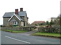
1
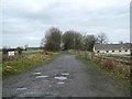
Scorton railway station (site)
Opened in 1846 by the York and Newcastle Railway on its branch line from Eryholme Junction to Richmond (Yorkshire), this station closed in 1969. View south west from the former level crossing towards Catterick Bridge and Richmond.
Image: © Nigel Thompson
Taken: 3 Feb 2013
0.02 miles
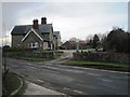
2
Former Station House, Scorton
Nearly a mile from the village, this was Scorton Station on the Richmond branch until 1969. The track bed follows the line of the current driveway.
Image: © Tony Simms
Taken: 13 May 2015
0.02 miles
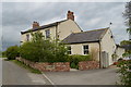
3
Former Scorton Station, North Yorkshire
The station was restored in recent years as a private house after closure in 1969. Photo looking west from the former level crossing.
Image: © mark harrington
Taken: 2 Jan 2006
0.02 miles
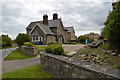
4
St Cuthberts House
Formerly the St Cuthberts Well public house.
Image: © Tony Simms
Taken: 13 May 2015
0.06 miles
5
Former Richmond Branch Line, Scorton Station
A view looking east along the former branch line from Richmond to Darlington, closed to passenger traffic in 1969 and freight a year later. The compound on the right is the site of the St Cuthberts Inn car park (closed circa 1999).
Image: © mark harrington
Taken: 2 Jan 2006
0.07 miles
6
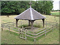
St. Cuthbert's Well : Cuddy Keld
In the parish of Uckerby. A classic Holy Well, near Scorton Station, with a keyhole shape, canopy and steps. The origins are unclear, but the site became a popular spa with the coming of the railway to Richmond in 1846. (recently restored). Cuddy Keld is the local name.
Image: © Hugh Mortimer
Taken: 6 Aug 2006
0.11 miles
7
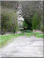
Bridleway near Scorton
The bridleway takes riders and walkers to New House Farm and onwards to Slopes Bridge.
Image: © Maigheach-gheal
Taken: 4 Apr 2011
0.14 miles