IMAGES TAKEN NEAR TO
Southside, RICHMOND, DL10 6DN
Introduction
This page details the photographs taken nearby to Southside, DL10 6DN by members of the Geograph project.
The Geograph project started in 2005 with the aim of publishing, organising and preserving representative images for every square kilometre of Great Britain, Ireland and the Isle of Man.

There are currently over 7.5m images from over14,400 individuals and you can help contribute to the project by visiting https://www.geograph.org.uk
Image Map (Loading...)


Getting Data...Please wait
Leaflet Map data © OpenStreetMap
Images are licensed for reuse under creativecommons.org/licenses/by-sa/2.0
Notes
- Clicking on the map will re-center to the selected point.
- The higher the marker number, the further away the image location is from the centre of the postcode.
Image Listing (51 Images Found)
Images are licensed for reuse under creativecommons.org/licenses/by-sa/2.0
Image
Details
Distance
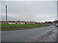
1
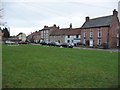
Houses south-east of Scorton village green
The B1263 separates this fragment of the green from the main part.
Image: © Christine Johnstone
Taken: 14 Dec 2010
0.01 miles
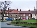
2
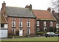
Houses on the south side of Scorton Green
Scorton has a number of attractive village houses, including these on the south side of the green. Both probably 18th century, the left hand house having 'blank' windows on the second floor, which were presumably added for effect. I am informed by a relative of former owners that the second floor windows were originally actual windows in the servant's quarters but were filled in during modernisation.
Image: © Gordon Hatton
Taken: 14 Feb 2009
0.01 miles
3
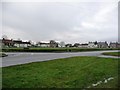
Village green, Scorton
Seen from the north-eastern corner.
Image: © Christine Johnstone
Taken: 14 Dec 2010
0.04 miles
4
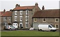
18th century house in Scorton
Three storey village house just off the green. The integral garage rather spoils the front elevation.
Image: © Gordon Hatton
Taken: 14 Feb 2009
0.04 miles
5
Village green, Scorton
From the road junction in the southern corner.
Image: © Christine Johnstone
Taken: 14 Dec 2010
0.05 miles
6
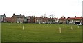
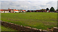
Cricket square on the green
The large, irregularly shaped village green is raised above the level of the surrounding roads and houses and is said to be one of only two such raised greens in England. There has probably been an open space here for centuries, but it is said that in the 18th century the raised green was converted from a rubbish dump by Scorton Grammar School, who then used it as a playing field. Village cricket matches are held here in summer as well as an annual feast in August.
Image: © Gordon Hatton
Taken: 14 Feb 2009
0.05 miles
7

The Richmond bus is waiting
The bus bound for Richmond waits at the stop in Scorton village centre. The green is to the right, with the village hall ahead of the bus and the public conveniences behind the bus.
Image: © Gordon Hatton
Taken: 14 Feb 2009
0.06 miles
8
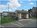
Bus stop facing Scorton Village Green
Sheltered seating with loose cushions
Image: © Peter Robinson
Taken: 8 Sep 2013
0.06 miles
9
Steps up to the green, Scorton
The main part of the village green is higher than the encircling road.
Image: © Christine Johnstone
Taken: 14 Dec 2010
0.06 miles
10
Scorton
Headed west for a change. A cycling foray into the flat farmlands of the Vale of Mowbray.
Sir Nikolaus Pevsner (1902-1983), the renowned architectural writer, described Scorton as having “a rather large, somewhat shapeless green”. But it is an unusual green in the fact that it is raised higher than the rest of the village. There are only two such other raised village greens in the whole of England (but another source does say there are actually three). The green was at one time the village rubbish tip before it was levelled and the wall built around it. It is surrounded by a one way system of the B1263 but is used regularly for cricket and football. Just don’t score a six or kick the ball out of touch.
The name Scorton is Anglo-Saxon. It was referred to as Scoretone in the Domesday Book. The ‘ton’ suffix is from the Old English tun for a farm or settlement. Opinion is divided about the origin of the scor element. One thought is that it meant short, as opposed the nearby village of Langton or ‘Long Tun’. Alternately it could come from the Old Norse word skor, meaning a rift in the rock or ravine. This hybridisation of Anglo-Saxon and Scandinavian names is not unusual. There are several examples in North Yorkshire. But I can not see where the ravine is around here.
The village was at one time home to two well known institutions. The Hospital of St John of God was founded in 1880 on the grounds of the former convent of St Clare. The current building was built in 1912/13. The chimneys can be seen in the photo on the skyline just left of the two trees. It is now a care home.
Image: © Mick Garratt
Taken: 28 May 2016
0.06 miles