IMAGES TAKEN NEAR TO
Scorton, RICHMOND, DL10 6DB
Introduction
This page details the photographs taken nearby to DL10 6DB by members of the Geograph project.
The Geograph project started in 2005 with the aim of publishing, organising and preserving representative images for every square kilometre of Great Britain, Ireland and the Isle of Man.

There are currently over 7.5m images from over14,400 individuals and you can help contribute to the project by visiting https://www.geograph.org.uk
Image Map
Images are licensed for reuse under creativecommons.org/licenses/by-sa/2.0
Notes
- Clicking on the map will re-center to the selected point.
- The higher the marker number, the further away the image location is from the centre of the postcode.
Image Listing (3 Images Found)
Images are licensed for reuse under creativecommons.org/licenses/by-sa/2.0
Image
Details
Distance
1
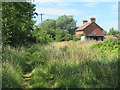
Cottage at The Grange
The paths as shown on the map and the reality on the ground are somewhat different here. My slightly older edition map shows the bridleway a few metres further south and actually in the water! West from here the path is shown as being to the left of fences and close by the lake edge, but that is impassable and the route appears to keep to the right of any fence.
Image: © Gordon Hatton
Taken: 8 Aug 2020
0.00 miles
2
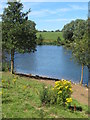
Large pond or small lake?
This must also be a flooded former gravel quarry, but much smaller than those nearby. There are extensive areas of gravel extraction in this area and near to Bolton on Swale. I suspect the deposits are a remnant of the last ice age when the Stainmore glacier would have met other ice in this neighbourhood originating both from the direction of the North Sea and from Swaledale, thus leaving large deposits of moraine material including gravels.
Image: © Gordon Hatton
Taken: 8 Aug 2020
0.07 miles
3
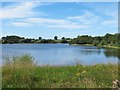
Former gravel pit south of The Grange
The largest of the old gravel pits near The Grange and already beginning to look like a natural lake with mature vegetation growth around the margins and a large number of wildfowl in residence.
Image: © Gordon Hatton
Taken: 8 Aug 2020
0.10 miles