IMAGES TAKEN NEAR TO
Reeth Road Caravan Park, RICHMOND, DL10 4TN
Introduction
This page details the photographs taken nearby to Reeth Road Caravan Park, DL10 4TN by members of the Geograph project.
The Geograph project started in 2005 with the aim of publishing, organising and preserving representative images for every square kilometre of Great Britain, Ireland and the Isle of Man.

There are currently over 7.5m images from over14,400 individuals and you can help contribute to the project by visiting https://www.geograph.org.uk
Image Map (Loading...)


Getting Data...Please wait
Leaflet Map data © OpenStreetMap
Images are licensed for reuse under creativecommons.org/licenses/by-sa/2.0
Notes
- Clicking on the map will re-center to the selected point.
- The higher the marker number, the further away the image location is from the centre of the postcode.
Image Listing (42 Images Found)
Images are licensed for reuse under creativecommons.org/licenses/by-sa/2.0
Image
Details
Distance
1
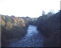
River Swale at Round Howe
Looking eastwards and downstream from the footbridge.
Image: © Trevor Rickard
Taken: Unknown
0.06 miles
2
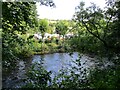
Richmond Caravan Park over the River Swale
Image: © Martin Dawes
Taken: 11 Sep 2017
0.09 miles
3

River Swale downstream
The River Swale heading towards Richmond as seen from a footbridge north-west of a minor hill, Round Howe.
Image: © Trevor Littlewood
Taken: 20 Dec 2016
0.10 miles
4
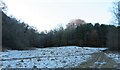
Round Howe
The small wooded hill [centre right] of Round Howe is situated close to the right bank of the Swale and is unusual in that it is cut off from the hills behind it by a valley which makes a semi-circular curve around the back of the hill, the eastern end of the valley seen here centre left. This must mark an old meander course of the Swale, but the valley floor is now considerably higher than the nearby river.
Image: © Gordon Hatton
Taken: 5 Jan 2022
0.10 miles
5
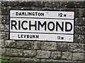
Old Village Signpost by the A6108, Reeth Road, Richmond
No finial - by the A6108, in parish of Richmond (Richmondshire District), Reeth Road, Richmond. At junction with Coronation Place, on grass verge, set in plinth, North side of road.
Surveyed
Milestone Society National ID: YN_NZ1501
Image: © K Hackett
Taken: 11 Oct 2017
0.10 miles
6
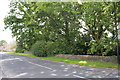
Reeth Road (A6108)
There is an OS benchmark Image on the stone wall, opposite house #69
Image: © Roger Templeman
Taken: 23 Aug 2012
0.10 miles
7
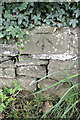
Benchmark on wall on south side of Reeth Road
Ordnance Survey cut mark benchmark described on the Bench Mark Database at http://www.bench-marks.org.uk/bm44968
Image: © Roger Templeman
Taken: 23 Aug 2012
0.10 miles
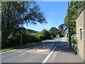
8

Reeth Road (A6108) at Richmond Cemetery
Looking eastward.
Image: © Peter Wood
Taken: 15 Jul 2015
0.10 miles
9
Reeth Road (A6108) at Richmond Cemetery
Looking westward.
Image: © Peter Wood
Taken: 15 Jul 2015
0.10 miles
10

Ordnance Survey Flush Bracket 11590
This can be found on the roadside wall of a cemetery building in Reeth Road.
For more detail see : http://www.bench-marks.org.uk/bm10316
Image: © Peter Wood
Taken: 15 Jul 2015
0.10 miles