IMAGES TAKEN NEAR TO
Fairfield Way, RICHMOND, DL10 4TB
Introduction
This page details the photographs taken nearby to Fairfield Way, DL10 4TB by members of the Geograph project.
The Geograph project started in 2005 with the aim of publishing, organising and preserving representative images for every square kilometre of Great Britain, Ireland and the Isle of Man.

There are currently over 7.5m images from over14,400 individuals and you can help contribute to the project by visiting https://www.geograph.org.uk
Image Map
Images are licensed for reuse under creativecommons.org/licenses/by-sa/2.0
Notes
- Clicking on the map will re-center to the selected point.
- The higher the marker number, the further away the image location is from the centre of the postcode.
Image Listing (15 Images Found)
Images are licensed for reuse under creativecommons.org/licenses/by-sa/2.0
Image
Details
Distance
1
Borough Road
Gallowfields Trading Estate.
Image: © Mick Garratt
Taken: 15 Mar 2009
0.03 miles
3
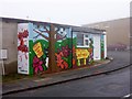
Moo-maa's and Dee-daa's
Is it just me, or is the thought of buying, even handling, a 'used toddler item', faintly alarming ? But among the industrial units on Gallowfields Trading Estate, looking rather bleak in the mist, are a surprising number of pleasant retail businesses of which this is only one, making a splash of attractive colour in the gloom which I'm sure wouldn't be tolerated in the tourist-orientated centre of Richmond.
Image: © Andy Waddington
Taken: 17 Feb 2011
0.04 miles
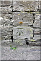
4
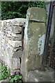
Benchmark on Quarry Road gatepost
Ordnance Survey cut mark benchmark described on the Bench Mark Database at http://www.bench-marks.org.uk/bm44977
Image: © Roger Templeman
Taken: 23 Aug 2012
0.08 miles
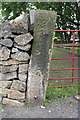
5
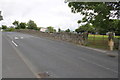
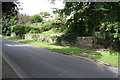
Quarry Road
There is an OS benchmark Image on the far gatepost
Image: © Roger Templeman
Taken: 23 Aug 2012
0.08 miles
6
Benchmark on wall of Green Howards Road
Ordnance Survey cut mark benchmark described on the Bench Mark Database at http://www.bench-marks.org.uk/bm44982
Image: © Roger Templeman
Taken: 23 Aug 2012
0.13 miles
7
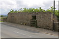
Wall (former barns) on Green Howards Road
There is an Ordnance Survey benchmark Image at the wall junction about 3m right of the wooden door.
Image: © Roger Templeman
Taken: 23 Aug 2012
0.13 miles
8
#1 Quarry Road
There is an Ordnance Survey cut mark benchmark http://www.bench-marks.org.uk/bm44978 on the corner of the house hidden behind a wooden post
Image: © Roger Templeman
Taken: 23 Aug 2012
0.17 miles
9
Hurgill Road
There is an OS benchmark Image on the left hand side gatepost beside the matal gate at the right hand side of the image
Image: © Roger Templeman
Taken: 23 Aug 2012
0.20 miles
10
Benchmark on gatepost, Hurgill Road
Ordnance Survey cut mark benchmark described on the Bench Mark Database at http://www.bench-marks.org.uk/bm44980
Image: © Roger Templeman
Taken: 23 Aug 2012
0.20 miles