IMAGES TAKEN NEAR TO
Tudor Road, RICHMOND, DL10 4NG
Introduction
This page details the photographs taken nearby to Tudor Road, DL10 4NG by members of the Geograph project.
The Geograph project started in 2005 with the aim of publishing, organising and preserving representative images for every square kilometre of Great Britain, Ireland and the Isle of Man.

There are currently over 7.5m images from over14,400 individuals and you can help contribute to the project by visiting https://www.geograph.org.uk
Image Map
Images are licensed for reuse under creativecommons.org/licenses/by-sa/2.0
Notes
- Clicking on the map will re-center to the selected point.
- The higher the marker number, the further away the image location is from the centre of the postcode.
Image Listing (112 Images Found)
Images are licensed for reuse under creativecommons.org/licenses/by-sa/2.0
Image
Details
Distance
1
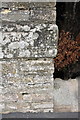
Benchmark on wall angle next to #21 Beechfield Road
The Ordnance Survey cut mark benchmark is on an inscribed stone (the last word is 'SOUTH') and is described on the Bench Mark Database at http://www.bench-marks.org.uk/bm44984
Image: © Roger Templeman
Taken: 23 Aug 2012
0.09 miles
2
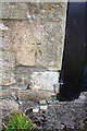
Benchmark on garage off Beechfield Road
Ordnance Survey cut mark benchmark described on the Bench Mark Database at http://www.bench-marks.org.uk/bm78228
Image: © Roger Templeman
Taken: 18 Aug 2016
0.09 miles
3
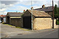
Garage on lane from Beechfield Road
There is an OS benchmark Image on a stone on the left hand side of the garage door
Image: © Roger Templeman
Taken: 18 Aug 2016
0.09 miles
4
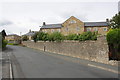
Housing provided by converted barracks, Beechfield Road
There is an OS benchmark Image on the inscribed stone inserted in the wall end near the right hand side of the image
Image: © Roger Templeman
Taken: 23 Aug 2012
0.10 miles
5
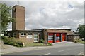
Richmond fire station
Richmond fire station, Gallowgate, Richmond, North Yorkshire
Image: © Kevin Hale
Taken: 3 Aug 2010
0.11 miles
6
![Richmond buildings [1]](https://s1.geograph.org.uk/geophotos/07/27/68/7276857_f3ec709f_120x120.jpg)
Richmond buildings [1]
The Eleanor Bowes Hospital, number 8 Anchorage Hill, is an almshouse founded in 1607 for three widows. The building incorporating the remains of the 12th century chapel to St Edmund the King. Constructed of rubble stone with ashlar buttresses under a stone slate roof. There is a blocked 14th century window with ogee tracery in the east gable end. Inside is an early 17th century fireplace. Listed, grade II*, with details at: https://historicengland.org.uk/listing/the-list/list-entry/1289900
Richmond is a picturesque market town in North Yorkshire, some 13 miles northwest of Northallerton and about 11½ miles southwest of Darlington. Set on the north bank of the River Swale, the town is on the edge of the Yorkshire Dales National Park, and is marketed as the Gateway to the Dales. Richmond was founded in 1071 and the castle was completed in 1086. Tourism is important to the local economy, as is the influence of the nearby Catterick Garrison army base. A traditional market operates every Saturday in the large cobbled marketplace.
Image: © Michael Dibb
Taken: 18 Jun 2022
0.12 miles
7
![Richmond buildings [2]](https://s2.geograph.org.uk/geophotos/07/27/68/7276858_b6bc1ad5_120x120.jpg)
Richmond buildings [2]
The Eleanor Bowes Hospital, number 8 Anchorage Hill, is an almshouse founded in 1607 for three widows. The building incorporating the remains of the 12th century chapel to St Edmund the King. Constructed of rubble stone with ashlar buttresses under a stone slate roof. There is a blocked 14th century window with ogee tracery in the east gable end. Inside is an early 17th century fireplace. Listed, grade II*, with details at: https://historicengland.org.uk/listing/the-list/list-entry/1289900
Richmond is a picturesque market town in North Yorkshire, some 13 miles northwest of Northallerton and about 11½ miles southwest of Darlington. Set on the north bank of the River Swale, the town is on the edge of the Yorkshire Dales National Park, and is marketed as the Gateway to the Dales. Richmond was founded in 1071 and the castle was completed in 1086. Tourism is important to the local economy, as is the influence of the nearby Catterick Garrison army base. A traditional market operates every Saturday in the large cobbled marketplace.
Image: © Michael Dibb
Taken: 18 Jun 2022
0.12 miles
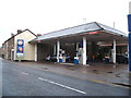
9
Town Road, Richmond
The Highways Maintenance Dept. transit had broken down on the island.
Image: © Mick Garratt
Taken: 16 Sep 2006
0.12 miles
10
![Richmond houses [14]](https://s0.geograph.org.uk/geophotos/07/27/68/7276868_d636f367_120x120.jpg)
Richmond houses [14]
Numbers 4 and 6 Anchorage Hill, were originally three, or perhaps four cottages, now combined into two. Built in the late 18th or early 19th century. Number 4, on the right, is constructed of rubble stone with brick arches to the openings. Number 6 is of rendered rubble stone. Both have Welsh slate roofs. Number 4 has
a carved medieval head and a weathered coat of arms. Listed, grade II, with details at: https://historicengland.org.uk/listing/the-list/list-entry/1131280
Richmond is a picturesque market town in North Yorkshire, some 13 miles northwest of Northallerton and about 11½ miles southwest of Darlington. Set on the north bank of the River Swale, the town is on the edge of the Yorkshire Dales National Park, and is marketed as the Gateway to the Dales. Richmond was founded in 1071 and the castle was completed in 1086. Tourism is important to the local economy, as is the influence of the nearby Catterick Garrison army base. A traditional market operates every Saturday in the large cobbled marketplace.
Image: © Michael Dibb
Taken: 18 Jun 2022
0.13 miles