IMAGES TAKEN NEAR TO
Heather Lea, STANLEY, DH9 9XN
Introduction
This page details the photographs taken nearby to Heather Lea, DH9 9XN by members of the Geograph project.
The Geograph project started in 2005 with the aim of publishing, organising and preserving representative images for every square kilometre of Great Britain, Ireland and the Isle of Man.

There are currently over 7.5m images from over14,400 individuals and you can help contribute to the project by visiting https://www.geograph.org.uk
Image Map (Loading...)


Getting Data...Please wait
Leaflet Map data © OpenStreetMap
Images are licensed for reuse under creativecommons.org/licenses/by-sa/2.0
Notes
- Clicking on the map will re-center to the selected point.
- The higher the marker number, the further away the image location is from the centre of the postcode.
Image Listing (28 Images Found)
Images are licensed for reuse under creativecommons.org/licenses/by-sa/2.0
Image
Details
Distance
1

Pillbox at Flint Hill
This WW2 pillbox was sited on a ridge overlooking the main road and Flint Hill crossroads.
Image: © Robert Graham
Taken: 9 Mar 2012
0.11 miles
2
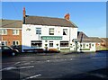
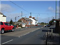
The Prince of Wales, Flint Hill
There has been a pub here for over 150 years. The 1861 OS map shows The Bloodhound Inn at this spot. However, I doubt if this is the building from that time, it's more likely to be a late Victorian or Edwardian replacement.
Image: © Robert Graham
Taken: 24 Jan 2022
0.13 miles

4

Walkway, Mountsett Crematorium
Sheltered access to the chapel.
Image: © Pauline E
Taken: 2 May 2013
0.14 miles
5
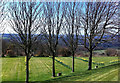
Leafless trees, early May
Daffodils still blooming and leafless trees - signs of a long winter, which thankfully seems to have come to an end. View from the grounds at Mountsett Crematorium.
Image: © Pauline E
Taken: 2 May 2013
0.15 miles
6
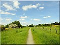
Looking along the Bowes Railway Path
At Hill Top, Dipton on a nice early summer day. The path follows the course of the old railway, a very early one.
Image: © Robert Graham
Taken: 6 Jun 2014
0.15 miles
7
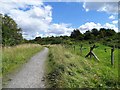
Looking north along the path at Mountsett Fell
This area to the north of Dipton village was once lowland heath, but is now much reduced and covered in scrub.
Image: © Robert Graham
Taken: 3 Aug 2020
0.16 miles
9
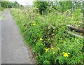
Wild flowers beside the footpath at Mountsett
Tansy and other flowers growing alongside the path along Mounsett Fell at Dipton.
Image: © Robert Graham
Taken: 3 Aug 2020
0.16 miles
10

Bowes Railway Path at Dipton
The Bowes Railway was one of the oldest railways in the world, sections of which were constructed by George Stephenson in 1826, and extended from Pontop to the Tyne at Jarrow. In 1842 it was bought and restored by John Bowes and Partners (hence the name). As the coal industry declined, so did use of the railway and the last section of the line was abandoned in the 1970s.
The trackbed is now being converted into a cycle- and foot-path running from Dipton via Burnopfield, Kibblesworth, Birtley and Springwell to Jarrow. It forms Regional Route 11 of the National Cycle Network. At present, much of the path is of poor standard, only suitable for mountain bikes.
Image: © Oliver Dixon
Taken: 28 Feb 2014
0.17 miles