IMAGES TAKEN NEAR TO
Martha Street, STANLEY, DH9 9TT
Introduction
This page details the photographs taken nearby to Martha Street, DH9 9TT by members of the Geograph project.
The Geograph project started in 2005 with the aim of publishing, organising and preserving representative images for every square kilometre of Great Britain, Ireland and the Isle of Man.

There are currently over 7.5m images from over14,400 individuals and you can help contribute to the project by visiting https://www.geograph.org.uk
Image Map
Images are licensed for reuse under creativecommons.org/licenses/by-sa/2.0
Notes
- Clicking on the map will re-center to the selected point.
- The higher the marker number, the further away the image location is from the centre of the postcode.
Image Listing (42 Images Found)
Images are licensed for reuse under creativecommons.org/licenses/by-sa/2.0
Image
Details
Distance
1
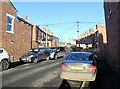
Steep terraces at Tantobie
These old terraced streets run up the steep slope between South View and Front Street in the village.
Image: © Robert Graham
Taken: 24 Jan 2022
0.02 miles
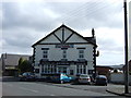
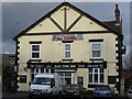
3
Oak Tree Inn, Tantobie
A pub in the centre of the village of Tantobie.
Image: © Graham Robson
Taken: 28 Oct 2018
0.03 miles
4
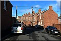
Owen Terrace, Tantobie
The rear of the terrace of houes on Owen Terrace seen from South View.
Image: © Graham Robson
Taken: 28 Oct 2018
0.04 miles
5
Oak Tree Inn, Tantobie
A Public House
Image: © Alex McGregor
Taken: 13 Apr 2010
0.05 miles
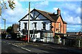
6
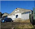
Hunters garage Tantobie
This garage on South View is the former site of Hunters Coaches, one of the oldest private bus companies in Britain. It operated between 1918 and 2016, when the one remaining bus service was taken over by local firm Stanley Travel. This used to be the depot for the buses.
Image: © Robert Graham
Taken: 24 Jan 2022
0.05 miles
7
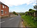
Looking down South View bank, Tantobie
Tantobie village is built on a slope leading up from the Stanley road, the B6173. When I lived near here in the 1950's, this road was always called "Kitty Reed's Bank", although I never knew why.
Image: © Robert Graham
Taken: 14 May 2014
0.05 miles
8
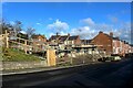
Building site, South View, Tantobie
New houses under construction on South View in Tantobie.
Image: © Graham Robson
Taken: 28 Oct 2018
0.05 miles
9
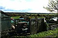
Allotments, Tantobie
Allotments on the southern side of South View in Tantobie.
Image: © Graham Robson
Taken: 28 Oct 2018
0.06 miles
10

Garage, South View, Tantobie
A garage offering auto repairs on South View in Tantobie.
Image: © Graham Robson
Taken: 28 Oct 2018
0.06 miles